IMAGES TAKEN NEAR TO
Margam, PORT TALBOT, SA13 2TW
Introduction
This page details the photographs taken nearby to SA13 2TW by members of the Geograph project.
The Geograph project started in 2005 with the aim of publishing, organising and preserving representative images for every square kilometre of Great Britain, Ireland and the Isle of Man.

There are currently over 7.5m images from over14,400 individuals and you can help contribute to the project by visiting https://www.geograph.org.uk
Image Map
Images are licensed for reuse under creativecommons.org/licenses/by-sa/2.0
Notes
- Clicking on the map will re-center to the selected point.
- The higher the marker number, the further away the image location is from the centre of the postcode.
Image Listing (16 Images Found)
Images are licensed for reuse under creativecommons.org/licenses/by-sa/2.0
Image
Details
Distance
1
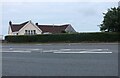
Bungalow on Margam Castle Way, Coed Hirwaun
Image: © David Howard
Taken: 21 Jul 2024
0.01 miles
3
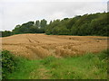
Wheat field ready for harvest near Margam
This small field, not even 2 acres in extent, is squeezed in between the A48 and Coal Brook, on the edge of Margam Country Park. The woodland on the right of the picture is Waungaled.
Image: © Simon Mortimer
Taken: 9 Aug 2012
0.04 miles
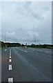
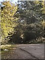
4
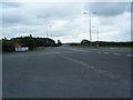
Road Junction on A48 near Margam Country Park
The road off the A48 leads to Twyn-yr-Hydd House and Garden Centre in Margam Country Park
Image: © Cedwyn Davies
Taken: 16 Sep 2006
0.08 miles
6
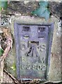
Ordnance Survey Flush Bracket (G3802)
This OS Flush Bracket can be found on wall NE side of the road. It marks a point 55.177m above mean sea level.
Image: © Adrian Dust
Taken: 10 Nov 2017
0.09 miles
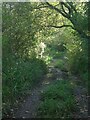
7
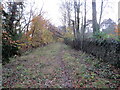
Hen heol i'r A48 / Old road to the A48
Hen heol sy bellach yn llwybr yn mynd i gyfeiriad yr A48.
An abandoned road, now a footpath, heads towards the A48.
Image: © Alan Richards
Taken: 15 Nov 2023
0.10 miles
8
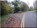
Trac yn gadael yr heol / Track exiting the road
Ar y chwith mae trac yn gadael yr heol. Hon oedd yr hen ffordd i'r A48 gerllaw.
On the left a track exits the road. This, in fact, was the old road to the nearby A48.
Image: © Alan Richards
Taken: 15 Nov 2023
0.12 miles
9
A route with public access at Waungaled, near Margam
The northernmost part of a path marked as a route with public access on Ordnance Survey maps. The route is possibly a disused section of a lane which ran southwards to meet the A48, which is where Ordnance Survey maps indicate the route ends. It should be noted that Google Street View images suggest that, if it once was, the route may no longer be accessible from the A road, even for those on foot.
Image: © eswales
Taken: 10 Oct 2022
0.13 miles
10
The start of a route with public access at Waungaled, near Margam
A picture taken on a road which runs close to the eastern boundary of Margam Country Park and lies on National Cycle Route 4. Just about visible in the image, amongst the shadows cast by tall trees to the side of the road, is a gate which lies at the northern end of what Ordnance Survey maps mark as a route with public access. The route is unsigned, and has a neglected feel.
Image: © eswales
Taken: 10 Oct 2022
0.13 miles