IMAGES TAKEN NEAR TO
Bryn, PORT TALBOT, SA13 2RT
Introduction
This page details the photographs taken nearby to SA13 2RT by members of the Geograph project.
The Geograph project started in 2005 with the aim of publishing, organising and preserving representative images for every square kilometre of Great Britain, Ireland and the Isle of Man.

There are currently over 7.5m images from over14,400 individuals and you can help contribute to the project by visiting https://www.geograph.org.uk
Image Map
Images are licensed for reuse under creativecommons.org/licenses/by-sa/2.0
Notes
- Clicking on the map will re-center to the selected point.
- The higher the marker number, the further away the image location is from the centre of the postcode.
Image Listing (8 Images Found)
Images are licensed for reuse under creativecommons.org/licenses/by-sa/2.0
Image
Details
Distance
1
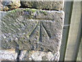
Ordnance Survey Cut Mark
This OS cut mark can be found on the south face of a barn at Penhydd Fawr Farm. It marks a point 209.102m above mean sea level. http://www.geograph.org.uk/photo/4420929
Image: © Adrian Dust
Taken: 9 Apr 2015
0.01 miles
2
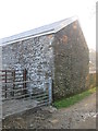
Barn, Penhydd Fawr Farm
There is an Ordnance Survey cut mark on the south face of the barn. http://www.geograph.org.uk/photo/4420926
Image: © Adrian Dust
Taken: 9 Apr 2015
0.01 miles
3
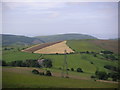
Penhydd Fawr Farm
Taken from the Penhydd MTB Trail
Image: © John Finch
Taken: 24 Jun 2006
0.05 miles
4
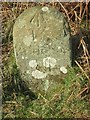
Old Milestone by Neath Road, west of Penhydd Fawr, Cwm Avon parish
Milestone by Neath Road byway, in parish of Cwm Avon (Neath Port Talbot District), 200m West of Penhydd Fawr farmhouse.
Inscription reads:-
To
Bridgend
XII
(??)
Rivet benchmark on top.
To be surveyed
Milestone Society National ID: GLA_BENT12
Image: © Milestone Society
Taken: Unknown
0.08 miles
5

Milestone - Pontrhydyfen 1
There is an OS rivet on the top of the milestone. It marks a point 223.284m above mean sea level.
Image: © Adrian Dust
Taken: 9 Apr 2015
0.09 miles
6
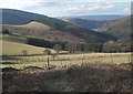
Upland around Cwm Ifan-bach
Farmland and forestry at the head of, and on the eastern slopes of, Cwm Ifan-bach. The latter is a short valley which descends to meet the Afan Valley at the village of Cwm.
The photograph looks more-or-less diagonally across the grid square from south east to north west. The hilltop with telecommunications mast to the left of the picture lies just outside the square in the north of Image
Image: © eswales
Taken: 1 Mar 2010
0.16 miles
7
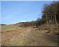
Track in Penhydd forestry area
A photograph taken at a spot by the very short stretch of forestry track in the south east corner of the grid square. The picture shows some of the Penhydd forestry area at Afan Forest Park.
Image: © eswales
Taken: 1 Mar 2010
0.17 miles
8
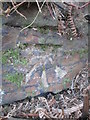
Ordnance Survey Cut Mark
This OS cut mark can be found on the dry stone wall to the NE of the track and NW of the gate. It marks a point 2-07.360m above mean sea level.
Image: © Adrian Dust
Taken: 9 Apr 2015
0.25 miles