IMAGES TAKEN NEAR TO
Villiers Street, PORT TALBOT, SA13 1YU
Introduction
This page details the photographs taken nearby to Villiers Street, SA13 1YU by members of the Geograph project.
The Geograph project started in 2005 with the aim of publishing, organising and preserving representative images for every square kilometre of Great Britain, Ireland and the Isle of Man.

There are currently over 7.5m images from over14,400 individuals and you can help contribute to the project by visiting https://www.geograph.org.uk
Image Map (Loading...)


Getting Data...Please wait
Leaflet Map data © OpenStreetMap
Images are licensed for reuse under creativecommons.org/licenses/by-sa/2.0
Notes
- Clicking on the map will re-center to the selected point.
- The higher the marker number, the further away the image location is from the centre of the postcode.
Image Listing (47 Images Found)
Images are licensed for reuse under creativecommons.org/licenses/by-sa/2.0
Image
Details
Distance
1
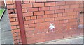
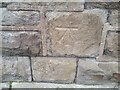
Ordnance Survey Cut Mark
This OS cut mark can be found on the SE angle of the school. It marks a point 15.127m above mean sea level.
Image: © Adrian Dust
Taken: 21 Feb 2021
0.05 miles

3
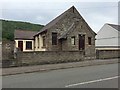
Gospel Hall
Gospel Hall in Ynys Street, Port Talbot.
Image: © Alan Hughes
Taken: 20 Jul 2017
0.09 miles
4

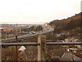
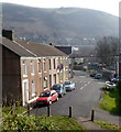
View from the A4107
Housing crowds the flat valley floor between the steep hillsides. Part of the raised section of the M4 can just be made out in the distance with Port Talbot beyond.
Image: © Andrew Hill
Taken: 23 Oct 2008
0.09 miles
5
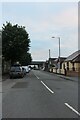
Ynys Street, Port Talbot
Looking towards the M4 flyover.
Image: © David Howard
Taken: 21 Jul 2024
0.10 miles
6
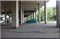
Port Talbot: view over the M4 viaduct
I took this picture through the passenger window while waiting at temporary traffic lights on the A4107. We see the M4 passing the town of Port Talbot, on concrete stilts.
Image: © Chris Downer
Taken: 1 Feb 2010
0.11 miles
7
Ford Road, Velindre, Port Talbot
Viewed from the Cwmavon Road end looking towards Jersey Street.
Image: © Jaggery
Taken: 2 Mar 2012
0.11 miles
8
Ordnance Survey Cut Mark
This OS cut mark can be found on the west face of the Chapel. It marks a point 42.779m above mean sea level.
Image: © Adrian Dust
Taken: 21 Feb 2021
0.12 miles
10
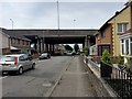
Ynys Street, Port Talbot
Housing lines this street which is bridged by the M4. The level of traffic noise is surprisingly low.
Image: © Alan Hughes
Taken: 20 Jul 2017
0.12 miles