IMAGES TAKEN NEAR TO
The Docks, PORT TALBOT, SA13 1RA
Introduction
This page details the photographs taken nearby to SA13 1RA by members of the Geograph project.
The Geograph project started in 2005 with the aim of publishing, organising and preserving representative images for every square kilometre of Great Britain, Ireland and the Isle of Man.

There are currently over 7.5m images from over14,400 individuals and you can help contribute to the project by visiting https://www.geograph.org.uk
Image Map
Images are licensed for reuse under creativecommons.org/licenses/by-sa/2.0
Notes
- Clicking on the map will re-center to the selected point.
- The higher the marker number, the further away the image location is from the centre of the postcode.
Image Listing (3 Images Found)
Images are licensed for reuse under creativecommons.org/licenses/by-sa/2.0
Image
Details
Distance
1
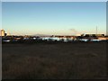
Port Talbot Docks
View across Port Talbot docks.
Image: © Alan Hughes
Taken: 1 Dec 2016
0.21 miles
2
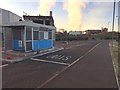
Traffic Control Office
Disused traffic control office at Port Talbot docklands.
Image: © Alan Hughes
Taken: 1 Dec 2016
0.22 miles
3
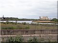
Port Talbot Docks
The docks are used by Port Talbot steelworks for the export of steel products and the import of raw materials for manufacturing steel, with cargoes of coal, iron ore, sand, cement, and processed and granulated slag.
Image: © Eirian Evans
Taken: 6 May 2019
0.22 miles