IMAGES TAKEN NEAR TO
Manor Street, PORT TALBOT, SA13 1AB
Introduction
This page details the photographs taken nearby to Manor Street, SA13 1AB by members of the Geograph project.
The Geograph project started in 2005 with the aim of publishing, organising and preserving representative images for every square kilometre of Great Britain, Ireland and the Isle of Man.

There are currently over 7.5m images from over14,400 individuals and you can help contribute to the project by visiting https://www.geograph.org.uk
Image Map (Loading...)


Getting Data...Please wait
Leaflet Map data © OpenStreetMap
Images are licensed for reuse under creativecommons.org/licenses/by-sa/2.0
Notes
- Clicking on the map will re-center to the selected point.
- The higher the marker number, the further away the image location is from the centre of the postcode.
Image Listing (86 Images Found)
Images are licensed for reuse under creativecommons.org/licenses/by-sa/2.0
Image
Details
Distance
1
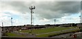
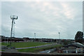
Aberavon Rugby Football Club Ground
Taken from the M4 motorway.
Image: © Clint Mann
Taken: 19 Aug 2014
0.06 miles
3
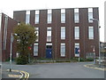
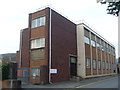
Port Talbot Telephone Exchange (2)
Taken from Tan-Y-Groes Street, this photo shows the extension which was added somewhile after the original building was built. The "No Entry" signs leading into Eagle Street can be seen on the left of the photo, whilst the two-way traffic signs are on the right.
Image: © David Hillas
Taken: 23 Aug 2011
0.08 miles
4
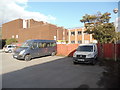
Rear of Telephone Exchange, Port Talbot
Taken from a parking area off Oakwood Lane, this photo shows the back of the town's telephone exchange in Eagle Street. The section on the right is the original building which would appear to date from the early 1960s or thereabouts, whilst the extension on the left of the photo would have been added later, possibly to cater for additional telephone traffic.
Image: © David Hillas
Taken: 8 Sep 2017
0.08 miles
5
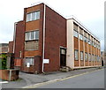
Port Talbot Telephone Exchange (1)
Situated in Eagle Street, this TE has the code SWPTB and provides telephone and broadband services to 16,677 residential and 507 non-residential premises in Port Talbot plus Aberavon, Bryn, Cwmavon, Goytre, Margam, Pontrhydyfen and Sandfields nearby. The wording "TELEPHONE EXCHANGE" and the BT warning notices in English and Welsh can be seen on the building. Its postcode is SA13 1AA.
Image: © David Hillas
Taken: 23 Aug 2011
0.08 miles
6

Ordnance Survey Cut Mark
This OS cut mark can be found on the wall NW side of the lane. It marks a point 8.903m above mean sea level.
Image: © Adrian Dust
Taken: 6 May 2020
0.10 miles
7

Ordnance Survey Cut Mark
This OS cut mark can be found on No48 Ty Draw Street. It marks a point 9.016m above mean sea level.
Image: © Adrian Dust
Taken: 6 May 2020
0.11 miles
8
Eagle Street telephone exchange, Port Talbot
British Telecom premises on the north side of the Royal Mail delivery office. http://www.geograph.org.uk/photo/2906870
Image: © Jaggery
Taken: 19 Apr 2012
0.13 miles
9
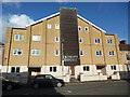
Trinity House Flats, Port Talbot
Located at 60-63 Tydraw Street SA13 1BR, this building replaced the Trinity Methodist Church during the Noughties, and has sixteen self-contained flats and car parking spaces.
Image: © David Hillas
Taken: 8 Sep 2017
0.13 miles
10
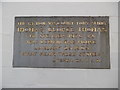
Plaque on George Thomas' birthplace, Port Talbot
This photo shows the plaque on the house at 36 Tydraw Street, Port Talbot where the Welsh politician George Thomas was born. It has the following wording:
THE RT.HON VISCOUNT TONYPANDY
THOMAS GEORGE THOMAS
MR.SPEAKER 1976 -83.
WAS BORN IN THIS HOUSE
JANUARY 29,1909
"WHAT MEAN THESE STONES"
JOSHUA CH.4. V.21
Image: © David Hillas
Taken: 8 Sep 2017
0.14 miles