IMAGES TAKEN NEAR TO
New Cut Road, SWANSEA, SA1 2DN
Introduction
This page details the photographs taken nearby to New Cut Road, SA1 2DN by members of the Geograph project.
The Geograph project started in 2005 with the aim of publishing, organising and preserving representative images for every square kilometre of Great Britain, Ireland and the Isle of Man.

There are currently over 7.5m images from over14,400 individuals and you can help contribute to the project by visiting https://www.geograph.org.uk
Image Map (Loading...)


Getting Data...Please wait
Leaflet Map data © OpenStreetMap
Images are licensed for reuse under creativecommons.org/licenses/by-sa/2.0
Notes
- Clicking on the map will re-center to the selected point.
- The higher the marker number, the further away the image location is from the centre of the postcode.
Image Listing (245 Images Found)
Images are licensed for reuse under creativecommons.org/licenses/by-sa/2.0
Image
Details
Distance
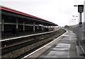
1
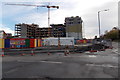
Student accommodation construction site in Swansea
A November 2013 view of the site on the corner of Morfa Road and New Cut Road.
Image: © Jaggery
Taken: 10 Nov 2013
0.02 miles
2
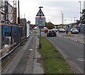
Fire station : stop when lights show, Swansea
The traffic sign is alongside New Cut Road. The lights are ahead, on the corner of Pottery Street, http://www.geograph.org.uk/photo/3739125 near the junction with The Strand, the location of Swansea Central Fire Station. http://www.geograph.org.uk/photo/3738745
Image: © Jaggery
Taken: 10 Nov 2013
0.02 miles
3
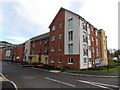
Pottery Street houses, Swansea
New housing located between New Cut Road and the River Tawe. The name Pottery Street has been revived. A street of that name (probably nearby rather than in this exact location) was demolished in the 1970s.
Image: © Jaggery
Taken: 10 Nov 2013
0.03 miles
4
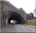
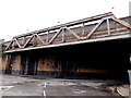
Under a railway viaduct near Swansea station
The 60 metre wide viaduct carries the South Wales main railway lines
over New Cut Road immediately NE of Swansea railway station.
Image: © Jaggery
Taken: 10 Nov 2013
0.04 miles
5
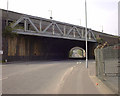
SE side of a railway viaduct near Swansea station
The 60 metre wide viaduct http://www.geograph.org.uk/photo/3739000 carries the South Wales main railway lines
over New Cut Road immediately NE of Swansea railway station.
Image: © Jaggery
Taken: 10 Nov 2013
0.06 miles
6
Railway viaducts over New Cut Road, Swansea
This 1998 view shows the main Swansea railway station platform viaduct to the rear and the box girder viaduct that used to link the Vale of Neath, GWR and LNWR routes together. Originally, this joint viaduct would have run towards Swansea Victoria (LNWR) station serving various wharves along the now filled in North Dock area.
Although the viaducts and tiling date back to the 1920s, New Cut Road as a through road did not exist until the 1960s. The road formerly known as Upper Strand would have terminated at the box girder bridge as the Swansea Canal intersected this view from left to right just beyond the lamp post until the 1950s.
Beyond the viaducts and in the distance, the original Upper Strand veered to the right to connect with the Hafod Bridge triangle. Due to the roadworks on the 1960s, New Cut Road does not have a road connection with the current Upper Strand.
Elephant Street and Bargeman's Row were accessed from the original Upper Strand, until New Cut Road cut these off totally. Remains of these former slum streets can still be seen.
Car hire company Godfrey Davies occupied one of the industrial units between the two railway viaducts in the distance until the 1980s.
Image: © vectorkraft
Taken: 8 May 1998
0.07 miles
7
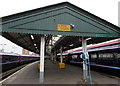
Warning - fragile roof at Swansea railway station
The canopy is over the SW end of platforms 2 and 3.
Staff who need to go on the roof must use duck or roof ladders and knee or crawling boards.
Image: © Jaggery
Taken: 13 Mar 2015
0.07 miles
8
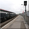
Swansea railway station signal PT 3174 BR
On platform 4, the easternmost platform at Swansea station.
PT indicates that the signal is controlled from Port Talbot.
Image: © Jaggery
Taken: 13 Jul 2019
0.07 miles
9
Signal PT479 at Swansea railway station
At the edge of platform 4. Behind the camera, the 9.33am train to Shrewsbury via the Heart of Wales Line awaits departure. http://www.geograph.org.uk/photo/4623536
Image: © Jaggery
Taken: 20 Aug 2015
0.07 miles
10
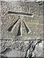
Ordnance Survey Cut Mark
This OS cut mark can be found on the railway wall to the NW of Morfa Road. It marks a point 9.354m above mean sea level.
Image: © Adrian Dust
Taken: 25 Oct 2013
0.07 miles