Railway viaducts over New Cut Road, Swansea
Introduction
The photograph on this page of Railway viaducts over New Cut Road, Swansea by vectorkraft as part of the Geograph project.
The Geograph project started in 2005 with the aim of publishing, organising and preserving representative images for every square kilometre of Great Britain, Ireland and the Isle of Man.

There are currently over 7.5m images from over 14,400 individuals and you can help contribute to the project by visiting https://www.geograph.org.uk
Railway viaducts over New Cut Road, Swansea
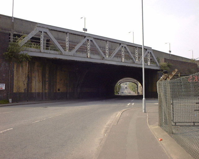
Image: © vectorkraft Taken: 8 May 1998
This 1998 view shows the main Swansea railway station platform viaduct to the rear and the box girder viaduct that used to link the Vale of Neath, GWR and LNWR routes together. Originally, this joint viaduct would have run towards Swansea Victoria (LNWR) station serving various wharves along the now filled in North Dock area. Although the viaducts and tiling date back to the 1920s, New Cut Road as a through road did not exist until the 1960s. The road formerly known as Upper Strand would have terminated at the box girder bridge as the Swansea Canal intersected this view from left to right just beyond the lamp post until the 1950s. Beyond the viaducts and in the distance, the original Upper Strand veered to the right to connect with the Hafod Bridge triangle. Due to the roadworks on the 1960s, New Cut Road does not have a road connection with the current Upper Strand. Elephant Street and Bargeman's Row were accessed from the original Upper Strand, until New Cut Road cut these off totally. Remains of these former slum streets can still be seen. Car hire company Godfrey Davies occupied one of the industrial units between the two railway viaducts in the distance until the 1980s.
Images are licensed for reuse under creativecommons.org/licenses/by-sa/2.0
Image Location
Latitude
51.626712
Longitude
-3.939157