IMAGES TAKEN NEAR TO
Cwmavon, PORT TALBOT, SA12 9YG
Introduction
This page details the photographs taken nearby to SA12 9YG by members of the Geograph project.
The Geograph project started in 2005 with the aim of publishing, organising and preserving representative images for every square kilometre of Great Britain, Ireland and the Isle of Man.

There are currently over 7.5m images from over14,400 individuals and you can help contribute to the project by visiting https://www.geograph.org.uk
Image Map
Images are licensed for reuse under creativecommons.org/licenses/by-sa/2.0
Notes
- Clicking on the map will re-center to the selected point.
- The higher the marker number, the further away the image location is from the centre of the postcode.
Image Listing (34 Images Found)
Images are licensed for reuse under creativecommons.org/licenses/by-sa/2.0
Image
Details
Distance
1
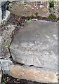
Ordnance Survey Rivet
This OS rivet can be found at the step of No60 The Craig. It marks a point 86.030m above mean sea level.
Image: © Adrian Dust
Taken: 20 May 2017
0.04 miles
2
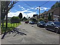
Pen y Banc, Cwmafan
Pen y Banc, a residential street on the outskirts of Cwmafan.
Image: © Alan Hughes
Taken: 20 Jul 2017
0.07 miles
3
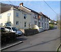
Northern end of Pwll-y-glaw, Cwmafan
Pwll-y-glaw is a residential street in the NE of Cwmafan. The British Lion pub http://www.geograph.org.uk/photo/2830031 is at centre right, at the northern end of the street.
Image: © Jaggery
Taken: 2 Mar 2012
0.08 miles
4
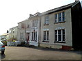
The British Lion pub, Cwmafan
Located on a street named Pwll-y-glaw in the NE corner of Cwmafan.
Image: © Jaggery
Taken: 2 Mar 2012
0.08 miles
5
Pwll y Glaw
The street name, Pwll y Glaw, takes its name from a stretch of the Afan river nearby. The name means 'Pool of Rain'.
Image: © Alan Hughes
Taken: 20 Jul 2017
0.08 miles
6
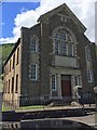
Rock Chapel
Rock Capel yr Annibynwyr, Cwmafan.
Image: © Alan Hughes
Taken: 20 Jul 2017
0.08 miles
7
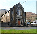
Rock chapel, Pwll-y-Glaw, Cwmavon
A plaque above the door is inscribed 'Rock Capel y Annibynwyr 1836-1931'
Capel y Annibynwyr is Welsh for Congregational Chapel.
Image: © Jaggery
Taken: 2 Mar 2012
0.08 miles
8
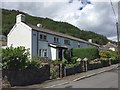
Pwll y Glaw houses, Cwmavon
The street name sign shows PWLL Y GLAW whereas the older nameplate
at first floor level next to the drainpipe shows PWLLYGLAW.
Image: © Jaggery
Taken: 2 Mar 2012
0.08 miles
9
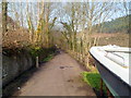
Path north from Pwll-y-glaw, Cwmafan
The path heads away from The British Lion pub. http://www.geograph.org.uk/photo/2830031
Image: © Jaggery
Taken: 2 Mar 2012
0.09 miles
10
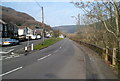
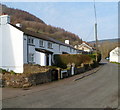
Pwll y Glaw, Cwmavon
Houses in Pwll y Glaw are set back from the B4286.
Image: © Jaggery
Taken: 2 Mar 2012
0.14 miles