IMAGES TAKEN NEAR TO
Tor-y-Mynydd, PORT TALBOT, SA12 8LE
Introduction
This page details the photographs taken nearby to Tor-y-Mynydd, SA12 8LE by members of the Geograph project.
The Geograph project started in 2005 with the aim of publishing, organising and preserving representative images for every square kilometre of Great Britain, Ireland and the Isle of Man.

There are currently over 7.5m images from over14,400 individuals and you can help contribute to the project by visiting https://www.geograph.org.uk
Image Map
Images are licensed for reuse under creativecommons.org/licenses/by-sa/2.0
Notes
- Clicking on the map will re-center to the selected point.
- The higher the marker number, the further away the image location is from the centre of the postcode.
Image Listing (29 Images Found)
Images are licensed for reuse under creativecommons.org/licenses/by-sa/2.0
Image
Details
Distance
1
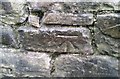
Ordnance Survey Cut Mark
This OS cut mark can be found on the wall NE side of Old Road. It marks a point 17.593m above mean sea level.
Image: © Adrian Dust
Taken: 25 May 2018
0.02 miles
2

Old Milestone, Former A48, Old Road, Baglan
The milestone is located behind the column on the verge at the apex of the Y-junction. Parish of Baglan (Neath Port Talbot District). Carved stone post, erected in the 19th century.
Inscription reads:-
WESTERN / DISTRICT / NEATH / 3 / ABERAVON / 5
Grade II listed by Cadw, Reference Number: 22812 https://cadwpublic-api.azurewebsites.net/reports/listedbuilding/FullReport?lang=&id=22812
Milestone Society National ID: GLA_NTAA03
Image: © Ron Shackell
Taken: Unknown
0.03 miles
3

Neath Port Talbot : Baglan Scenery
Looking across towards the Bagland suburbs from the M4 Motorway.
Image: © Lewis Clarke
Taken: 11 Apr 2014
0.06 miles
4

Port Talbot : The A48
Heading into Port Talbot on the A48.
Image: © Lewis Clarke
Taken: 23 Jul 2017
0.11 miles

6
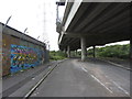
Road beneath the M4 flyover near Briton Ferry
From the OS and Google maps, the road arrangements are not obvious, but an industrial estate road runs directly beneath the M4 flyover for some of its length, seen here beside an electricity sub-station.
Image: © Gareth James
Taken: 24 Aug 2014
0.15 miles

8

Railtour at Baglan Bay
Pathfinder Tours' Taffy Tug 2 excursion covered a number of branch lines in South Wales with class 60 locomotives.
Here No. 60040 inches across the public footpath crossing beneath the M4 flyover just after coming through the gates into Baglan Bay sidings.
Image: © Gareth James
Taken: 24 Aug 2014
0.16 miles
9

Railtour at Baglan Bay
Pathfinder Tours' Taffy Tug 2 excursion covered a number of branch lines in South Wales with class 60 locomotives.
Here, No. 60040 crosses the public footpath crossing beneath the M4 flyover as it heads into Baglan Bay sidings.
Image: © Gareth James
Taken: 24 Aug 2014
0.16 miles
10

Neath Port Talbot : Industrial Estate
Looking towards a pylon and industrial estate off of the M4 Motorway.
Image: © Lewis Clarke
Taken: 10 Apr 2014
0.16 miles