IMAGES TAKEN NEAR TO
Alpha Place, PORT TALBOT, SA12 8DL
Introduction
This page details the photographs taken nearby to Alpha Place, SA12 8DL by members of the Geograph project.
The Geograph project started in 2005 with the aim of publishing, organising and preserving representative images for every square kilometre of Great Britain, Ireland and the Isle of Man.

There are currently over 7.5m images from over14,400 individuals and you can help contribute to the project by visiting https://www.geograph.org.uk
Image Map
Images are licensed for reuse under creativecommons.org/licenses/by-sa/2.0
Notes
- Clicking on the map will re-center to the selected point.
- The higher the marker number, the further away the image location is from the centre of the postcode.
Image Listing (11 Images Found)
Images are licensed for reuse under creativecommons.org/licenses/by-sa/2.0
Image
Details
Distance
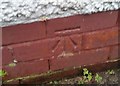
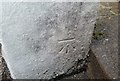
1
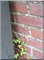
Ordnance Survey Cut Mark
This OS cut mark can be found on the wall between Nos40 & 42 Sycamore Crescent. It marks a point 43.577m above mean sea level.
Image: © Adrian Dust
Taken: 25 May 2018
0.03 miles
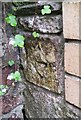
2
Ordnance Survey Cut Mark
This damaged OS cut mark can be found on No9 Hawthorn Avenue. It marks a point 38.067m above mean sea level.
Image: © Adrian Dust
Taken: 25 May 2018
0.07 miles
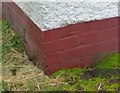
3
Ordnance Survey Cut Mark
This OS cut mark can be found on No4 Mayberry Road. It marks a point 35.134m above mean sea level.
Image: © Adrian Dust
Taken: 25 May 2018
0.07 miles
4
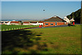
Baglan R.F.C. Field and Clubhouse
View of the Baglan R.F.C. clubhouse with Swansea Bay in the distance.
Image: © Cedwyn Davies
Taken: 15 Jul 2006
0.10 miles
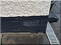
5
Ordnance Survey Cut Mark
This OS cut mark can be found on No65 Hawthorn Avenue. It marks a point 29.883m above mean sea level.
Image: © Adrian Dust
Taken: 25 May 2018
0.14 miles
6
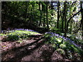
Bluebells in a clearing in woods near Baglan
Image: © Gareth James
Taken: 8 May 2016
0.18 miles
7
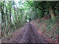
Coed Llansawel / Briton Ferry Woods
Llwybr cyhoeddus yng Nghoed Llansawel. Daw cangen ucheldir Llwybr Arfordir Cymru ar hyd y ffordd hon hefyd.
A public footpath in Briton Ferry Woods. An upland route of the Wales Coastal Path also comes this way.
Image: © Alan Richards
Taken: 6 Jul 2014
0.19 miles
8
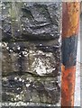
Ordnance Survey Cut Mark
This OS cut mark can be found on the post south side if the road. It marks a point 9.187m above mean sea level.
Image: © Adrian Dust
Taken: 25 May 2018
0.20 miles
9
Ordnance Survey Cut Mark
This OS cut mark can be found on No34 Thorney Road. It marks a point 29.435m above mean sea level.
Image: © Adrian Dust
Taken: 11 Jun 2020
0.21 miles
10
Ordnance Survey Cut Mark
This repositioned OS cut mark can be found on the post north side of the road. It marked a point 54.651m above mean sea level when in its original location.
Image: © Adrian Dust
Taken: 25 May 2018
0.24 miles