IMAGES TAKEN NEAR TO
Afandale, PORT TALBOT, SA12 7BN
Introduction
This page details the photographs taken nearby to Afandale, SA12 7BN by members of the Geograph project.
The Geograph project started in 2005 with the aim of publishing, organising and preserving representative images for every square kilometre of Great Britain, Ireland and the Isle of Man.

There are currently over 7.5m images from over14,400 individuals and you can help contribute to the project by visiting https://www.geograph.org.uk
Image Map (Loading...)


Getting Data...Please wait
Leaflet Map data © OpenStreetMap
Images are licensed for reuse under creativecommons.org/licenses/by-sa/2.0
Notes
- Clicking on the map will re-center to the selected point.
- The higher the marker number, the further away the image location is from the centre of the postcode.
Image Listing (8 Images Found)
Images are licensed for reuse under creativecommons.org/licenses/by-sa/2.0
Image
Details
Distance
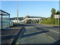
1

Footbridge over Ffordd Afan Way, Baglan
Image: © David Howard
Taken: 21 Jul 2024
0.07 miles
3

Sandfields Comprehensive School
Sandfields Comprehensive School, Aberavon.
Image: © Alan Hughes
Taken: 1 Dec 2016
0.15 miles
4
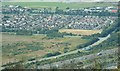
North Aberavon
Housing estate and sports ground - birds eye view from hills to the East.
Image: © Chris Shaw
Taken: Unknown
0.16 miles
5

Sandfields
Mainly Residential - from the North East
Image: © Chris Shaw
Taken: Unknown
0.20 miles
6
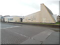
Sandfields Methodist Church
Situated in Western Avenue SA12 7NF, this Methodist Church was opened on Friday 14th October 1966 to meet the needs of people who lived on the nearby Sandfields housing estate that had been built earlier in the 1950s. It is one of nine churches in the Neath Port Talbot Methodist Circuit.
Image: © David Hillas
Taken: 6 Mar 2023
0.23 miles
7
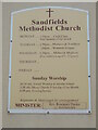
Information Board at Sandfields Methodist Church
This board is at the front of the Methodist Church in Western Avenue. It mentions that Sunday services are held at 10.30am and 6.00pm, although only morning services take place now. Also, it is stated on the board that other activities take place on Monday, Tuesday and Wednesday each week.
Image: © David Hillas
Taken: 6 Mar 2023
0.23 miles
8
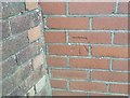
Ordnance Survey Cut Mark
This OS cut mark can be found on Flat 44 St Helier Drive. It marks a point 10.872m above mean sea level.
Image: © Adrian Dust
Taken: 4 May 2020
0.25 miles