IMAGES TAKEN NEAR TO
Clydach Avenue, NEATH, SA11 4LU
Introduction
This page details the photographs taken nearby to Clydach Avenue, SA11 4LU by members of the Geograph project.
The Geograph project started in 2005 with the aim of publishing, organising and preserving representative images for every square kilometre of Great Britain, Ireland and the Isle of Man.

There are currently over 7.5m images from over14,400 individuals and you can help contribute to the project by visiting https://www.geograph.org.uk
Image Map
Images are licensed for reuse under creativecommons.org/licenses/by-sa/2.0
Notes
- Clicking on the map will re-center to the selected point.
- The higher the marker number, the further away the image location is from the centre of the postcode.
Image Listing (63 Images Found)
Images are licensed for reuse under creativecommons.org/licenses/by-sa/2.0
Image
Details
Distance
1
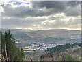
Across the Neath Valley
Overlooking Resolven.
Image: © Alan Hughes
Taken: 30 Jan 2023
0.03 miles
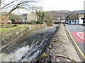
2
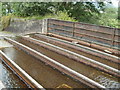
Grade II listed small aqueduct, Resolven
Located alongside the B4434, the aqueduct conveys Clydach Brook above the Vale of Neath railway. Grade II listed in 2003. The Royal Commission on the Ancient and Historical Monuments of Wales states:
"A cast-iron structure carrying a stream over the railway adjacent to the B4434 at Resolven. There are six main beams. There are 20 floor plates. Four side panels on each side; eight in all. These are lipped on each edge. The aqueduct is supported on masonry abutments, each having three dummy arches recessed into the face".
Image: © Jaggery
Taken: 31 Jul 2011
0.06 miles
3
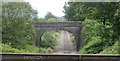
Stone railway bridge viewed across a cast-iron aqueduct, Resolven
The bridge and aqueduct http://www.geograph.org.uk/photo/2532159 cross above the Vale of Neath railway line. Viewed from the B4434.
Image: © Jaggery
Taken: 31 Jul 2011
0.06 miles
4
Clydach Brook aqueduct, Resolven
Viewed from a footbridge. The small aqueduct, http://www.geograph.org.uk/photo/2532159 just behind the large-bore pipe across the water, conveys the brook above the Vale of Neath railway. http://www.geograph.org.uk/photo/2532167
Four rail-like structures in the aqueduct can be seen, at right angles to the pipe.
Image: © Jaggery
Taken: 31 Jul 2011
0.06 miles
5
Clydach Brook and aqueduct at Resolven
Image: © Gareth James
Taken: 10 Mar 2018
0.06 miles
6
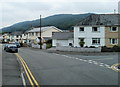
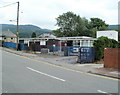
Corner of Ynys Fach Avenue and Clydach Avenue, Resolven
The right turn is into Clydach Avenue. http://www.geograph.org.uk/photo/2531902
Image: © Jaggery
Taken: 31 Jul 2011
0.06 miles
7
Clydach Avenue, Resolven
Viewed from the corner of Ynys Fach Avenue. Out of shot on the right is Clydach Brook. http://www.geograph.org.uk/photo/2531891
Image: © Jaggery
Taken: 31 Jul 2011
0.06 miles
8
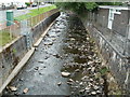
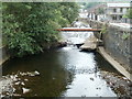
Clydach Brook, Resolven
The brook here flows between Resolven Health Centre http://www.geograph.org.uk/photo/2531871 and Clydach Avenue. http://www.geograph.org.uk/photo/2531902
The brook is a tributary of the River Neath, into which it flows about 300 metres behind the camera.
Image: © Jaggery
Taken: 31 Jul 2011
0.06 miles
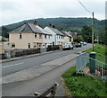
9
Resolven Health Centre
Located on Ynys Fach Avenue, on the west bank of Clydach Brook.
Image: © Jaggery
Taken: 31 Jul 2011
0.06 miles
10
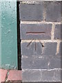
Ordnance Survey Cut Mark
This OS cut mark can be found on the SW parapet of the railway bridge. It marks a point 34.860m above mean sea level.
Image: © Adrian Dust
Taken: 11 Jan 2015
0.06 miles