IMAGES TAKEN NEAR TO
Heol Herbert, NEATH, SA11 4AG
Introduction
This page details the photographs taken nearby to Heol Herbert, SA11 4AG by members of the Geograph project.
The Geograph project started in 2005 with the aim of publishing, organising and preserving representative images for every square kilometre of Great Britain, Ireland and the Isle of Man.

There are currently over 7.5m images from over14,400 individuals and you can help contribute to the project by visiting https://www.geograph.org.uk
Image Map
Images are licensed for reuse under creativecommons.org/licenses/by-sa/2.0
Notes
- Clicking on the map will re-center to the selected point.
- The higher the marker number, the further away the image location is from the centre of the postcode.
Image Listing (47 Images Found)
Images are licensed for reuse under creativecommons.org/licenses/by-sa/2.0
Image
Details
Distance
1
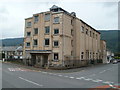
Resolven Miners Welfare Public Hall & Institute
This imposing building is on the corner of Neath Road and Coronation Avenue.
The site on which the building stands was acquired in 1925. The hall formerly housed a cinema and theatre on the first floor, with performances usually attracting a capacity audience of about 750.
The ground floor has had a games room, including billiards and snooker, a reading room and, since the early 1960s, a licensed bar.
Image: © Jaggery
Taken: 31 Jul 2011
0.01 miles
2
Coronation Avenue, Resolven
Viewed from the edge of the Miners Welfare building. http://www.geograph.org.uk/photo/2539650
Image: © Jaggery
Taken: 31 Jul 2011
0.01 miles
3
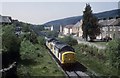
Coal empties for Cwmgwrach
Heading up the valley , the vale of Neath , a train of empty coal hoppers for the loading site at Cwmgwrach is pictured. The train is passing the former Resolven station site opened in 1851 and shut to passengers way back on the 21 March 1964. The line survived to move coal , however the trains are few and far between these days and it can be a very long wait to photograph movements on the line. Gritstone has also been moved in trains From Cwmgwrach on occasions.
Image: © roger geach
Taken: 15 May 1996
0.07 miles
4
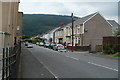
Neath Road houses, Resolven
Houses on the NE side of the road, between Coronation Road and Jerusalem chapel http://www.geograph.org.uk/photo/2539630 visible in the distance.
Image: © Jaggery
Taken: 31 Jul 2011
0.07 miles
5
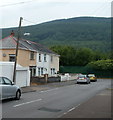
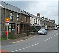
Heol Herbert, Resolven
Numbers 1-3 Heol Herbert are on the left. The road turns through 90 degrees ahead, at the green fence at the edge of a railway. The rest of the houses are around the bend.
Image: © Jaggery
Taken: 31 Jul 2011
0.07 miles
6
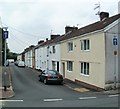
Railway Terrace, Resolven
The houses face a railway line, now used only for freight. Passenger services ended, and Resolven railway station closed, in 1964.
Image: © Jaggery
Taken: 31 Jul 2011
0.10 miles
7
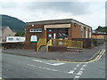
Resolven Library
Part of the Neath Port Talbot County Borough library service. Located on Neath Road (B4434).
"Join today nothing to pay" is the motto in the window.
Image: © Jaggery
Taken: 31 Jul 2011
0.13 miles
8
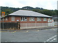
Resolven Building Blocks
Children's nursery located diagonally opposite Resolven Library. http://www.geograph.org.uk/photo/2539576 The building, occupying the NE corner of the Ynysfach Primary School site, was purpose built. Child care is provided for children up to the age of 12.
Image: © Jaggery
Taken: 31 Jul 2011
0.13 miles
9
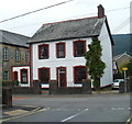
The Old Police Station, Resolven
Located on Neath Road (B4434), viewed from the edge of Resolven Library. http://www.geograph.org.uk/photo/2539576
Though painted over, the inscription COUNTY POLICE STATION 1901 is still clearly visible above the doorway. The building is now a 4-bedroom private residence. The two police cells have been converted into an office and utility room.
On the left is the edge of the Grade II listed Jerusalem chapel. http://www.geograph.org.uk/photo/2539630
Image: © Jaggery
Taken: 31 Jul 2011
0.13 miles
10
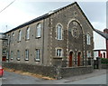
Jerusalem Independent Chapel, Resolven
Located on Neath Road (B4434). Designed by architect Thomas Thomas of Landore, the chapel dates from 1875. It was Grade II listed in March 2000.
The white building at the right edge is the former County Police Station. http://www.geograph.org.uk/photo/2539620
Image: © Jaggery
Taken: 31 Jul 2011
0.13 miles