IMAGES TAKEN NEAR TO
Gnoll Crescent, NEATH, SA11 3TF
Introduction
This page details the photographs taken nearby to Gnoll Crescent, SA11 3TF by members of the Geograph project.
The Geograph project started in 2005 with the aim of publishing, organising and preserving representative images for every square kilometre of Great Britain, Ireland and the Isle of Man.

There are currently over 7.5m images from over14,400 individuals and you can help contribute to the project by visiting https://www.geograph.org.uk
Image Map
Images are licensed for reuse under creativecommons.org/licenses/by-sa/2.0
Notes
- Clicking on the map will re-center to the selected point.
- The higher the marker number, the further away the image location is from the centre of the postcode.
Image Listing (54 Images Found)
Images are licensed for reuse under creativecommons.org/licenses/by-sa/2.0
Image
Details
Distance
2
Footbridge over Gnoll Brook, Neath
From Gnoll Drive on this side to Woodside Avenue.
Image: © Jaggery
Taken: 16 Feb 2014
0.07 miles
3
Gnoll Brook, Neath
Viewed from this http://www.geograph.org.uk/photo/3951173 footbridge looking towards its disused predecessor http://www.geograph.org.uk/photo/3951084
Image: © Jaggery
Taken: 16 Feb 2014
0.08 miles
4
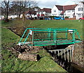
Green footbridge over Gnoll Brook, Neath
From Gnoll Drive on this side to Woodside Avenue. A notice on the bridge shows NO PUBLIC ACCESS.
A public access footbridge across the brook is in the background.
Image: © Jaggery
Taken: 16 Feb 2014
0.09 miles
5
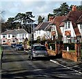
Gnoll Gates War Memorial, Neath
At the edge of Gnoll Estate Country Park, near Gnoll Drive and Woodside Avenue.
Image: © Jaggery
Taken: 16 Feb 2014
0.10 miles
6
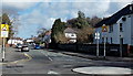
Beechwood Avenue, Neath
Looking NE past the mini-roundabout at the Cimla Road and Westernmoor Road crossroads.
Image: © Jaggery
Taken: 16 Feb 2014
0.10 miles
7
Woodside Avenue, Neath
Looking towards Beechwood Avenue.
Image: © Jaggery
Taken: 16 Feb 2014
0.10 miles
8
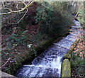
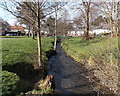
Stepped channel from a pond to Gnoll Brook, Neath
Excess water http://www.geograph.org.uk/photo/3951305 from a pond fed by Gnoll Brook tumbles down the channel to rejoin the brook ahead.
Image: © Jaggery
Taken: 16 Feb 2014
0.13 miles
9
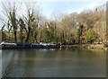
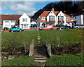
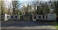
Pondside parking area in Gnoll Estate Country Park, Neath
This is one of three ponds (or small lakes) in the country park. It is fed by Gnoll Brook.
Image: © Jaggery
Taken: 16 Feb 2014
0.13 miles
10
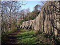
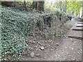
Buttressed wall, Gnoll
The buttressed wall at the Gnoll Country Park.
Image: © Robert Davies
Taken: 11 Dec 2001
0.13 miles