IMAGES TAKEN NEAR TO
Cwrt Y Cawr, NEATH, SA11 2UQ
Introduction
This page details the photographs taken nearby to Cwrt Y Cawr, SA11 2UQ by members of the Geograph project.
The Geograph project started in 2005 with the aim of publishing, organising and preserving representative images for every square kilometre of Great Britain, Ireland and the Isle of Man.

There are currently over 7.5m images from over14,400 individuals and you can help contribute to the project by visiting https://www.geograph.org.uk
Image Map
Images are licensed for reuse under creativecommons.org/licenses/by-sa/2.0
Notes
- Clicking on the map will re-center to the selected point.
- The higher the marker number, the further away the image location is from the centre of the postcode.
Image Listing (10 Images Found)
Images are licensed for reuse under creativecommons.org/licenses/by-sa/2.0
Image
Details
Distance
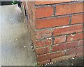
1
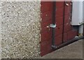
Ordnance Survey Cut Mark
This OS cut mark can be found on No55 Olive Branch Crescent. It marks a point 23.525m above mean sea level.
Image: © Adrian Dust
Taken: 6 Feb 2021
0.09 miles
2
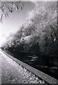
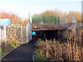
Neath Canal
Part of the disused canal way
Image: © steven beavis
Taken: 10 Sep 2007
0.15 miles
3
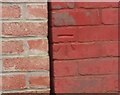
Ordnance Survey Cut Mark
This OS cut mark can be found on No14 Olive Branch Crescent. It marks a point 24.652m above mean sea level.
Image: © Adrian Dust
Taken: 6 Feb 2021
0.20 miles
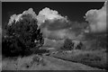
5
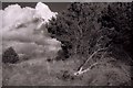
Camlas Castell Nedd / Neath Canal
Camlas Castell Nedd yn mynd o dan bont reilffordd. Cwblheuwyd y gamlas yn 1799 er cludo glo i lawr y cwm i Giants Grave. Fe'i caewyd yn 1934. Mae'r llwybr halio bellach yn ffordd beicio.
The Neath Canal going under a railway bridge. Completed in 1799 the canal transported coal from the Vale of Neath to Giants Grave. The former tow path is today a cycle way.
Image: © Alan Richards
Taken: 10 Jan 2020
0.22 miles
6
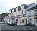
Spar store in former hotel, Briton Ferry
Spar at 175 Pantyrhreol occupies the former Grandison Hotel building.
Image: © Jaggery
Taken: 19 Feb 2011
0.24 miles
7
Ace Musicpool, Briton Ferry
Located on the corner of Cwrt Sart (A474) and Farm Road. The business specialises in the sale, service and hire of pool tables, snooker tables and jukeboxes.
Image: © Jaggery
Taken: 19 Feb 2011
0.24 miles
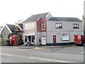
8
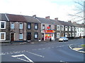
Conspicuous convenience store, Pantyrheol, Neath
A colourful Sheena convenience store and off-licence, at 139 Pantyrheol, stands out in the midst of the greys of the surrounding houses.
Image: © Jaggery
Taken: 19 Feb 2011
0.24 miles
9
Ordnance Survey Cut Mark
This OS cut mark can be found on No52 Glanymor Street. It marks a point 35.540m above mean sea level.
Image: © Adrian Dust
Taken: 6 Feb 2021
0.24 miles