IMAGES TAKEN NEAR TO
Ynysymaerdy Road, NEATH, SA11 2TL
Introduction
This page details the photographs taken nearby to Ynysymaerdy Road, SA11 2TL by members of the Geograph project.
The Geograph project started in 2005 with the aim of publishing, organising and preserving representative images for every square kilometre of Great Britain, Ireland and the Isle of Man.

There are currently over 7.5m images from over14,400 individuals and you can help contribute to the project by visiting https://www.geograph.org.uk
Image Map
Images are licensed for reuse under creativecommons.org/licenses/by-sa/2.0
Notes
- Clicking on the map will re-center to the selected point.
- The higher the marker number, the further away the image location is from the centre of the postcode.
Image Listing (15 Images Found)
Images are licensed for reuse under creativecommons.org/licenses/by-sa/2.0
Image
Details
Distance
1
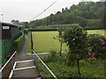
Ynysmaerdy Bowling Club
Clubhouse and green at Ynysmaerdy Bowling Club.
Image: © Alan Hughes
Taken: 16 May 2017
0.04 miles

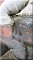
3
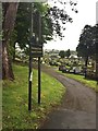
Ordnance Survey Rivet
This OS rivet can be found on the wall of Ynysmaerdy Cemetery. It marks a point 22.204m above mean sea level.
Image: © Adrian Dust
Taken: 23 Aug 2016
0.06 miles
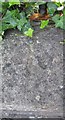
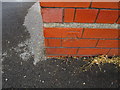
4
Ordnance Survey Rivet
This OS rivet can be found on the front of No24 Ynysmaerdy Road. It marks a point 13.579m above mean sea level.
Image: © Adrian Dust
Taken: 23 Aug 2016
0.13 miles
5
Ynysmaerdy Cemetery
North-eastern entrance to Ynysmaerdy Cemetery.
Image: © Alan Hughes
Taken: 16 May 2017
0.14 miles
6
Ordnance Survey Cut Mark
This OS cut mark can be found on the SE face of a building at Cwrt Sart Community Comprehensive School. It marks a point 10.443m above mean sea level.
Image: © Adrian Dust
Taken: 15 Jun 2016
0.14 miles
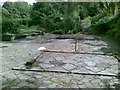
7

Cwrt Sart Comprehensive School
Piles of rubble - all that remains of Cwrt Sart School which closed in August 2016.
Image: © Alan Hughes
Taken: 16 May 2017
0.15 miles
8
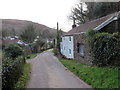
Heol Pant Howell Ddu / Pant Howell Ddu Road
Heol o'r enw Pant Howell Ddu yn Ynysmaerdy.
A road known as Pant Howell Ddu (trans. black Howell's hollow) in Ynysmaerdy (trans. steward's river meadow).
Image: © Alan Richards
Taken: 10 Jan 2020
0.15 miles
9
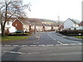
Tyla Road, Briton Ferry
Viewed from the corner of the A474, here named Cwrt Sart.
Image: © Jaggery
Taken: 19 Feb 2011
0.19 miles