IMAGES TAKEN NEAR TO
Rockingham Terrace, NEATH, SA11 2PB
Introduction
This page details the photographs taken nearby to Rockingham Terrace, SA11 2PB by members of the Geograph project.
The Geograph project started in 2005 with the aim of publishing, organising and preserving representative images for every square kilometre of Great Britain, Ireland and the Isle of Man.

There are currently over 7.5m images from over14,400 individuals and you can help contribute to the project by visiting https://www.geograph.org.uk
Image Map
Images are licensed for reuse under creativecommons.org/licenses/by-sa/2.0
Notes
- Clicking on the map will re-center to the selected point.
- The higher the marker number, the further away the image location is from the centre of the postcode.
Image Listing (65 Images Found)
Images are licensed for reuse under creativecommons.org/licenses/by-sa/2.0
Image
Details
Distance
1
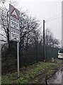
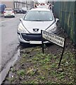
Humps warning sign, Rockingham Terrace, Briton Ferry
The sign facing Osterley Street shows humps for 440 yards to the left,
for 90 yards to the right. The text is also in Welsh.
Image: © Jaggery
Taken: 14 Feb 2024
0.03 miles
2
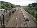
Briton Ferry railway station
Opened in 1935 by the Great Western Railway on the line from Cardiff to Swansea, this station replaced an earlier one about 500m to the south. It closed in 1964, but was rebuilt and reopened by British Rail in 1994.
View south towards Baglan and Cardiff. The left hand (Cardiff-bound) platform is roughly on the site of the 1935 station (see Image]), the right hand one is slightly further north.
Image: © Nigel Thompson
Taken: 16 Aug 2014
0.04 miles
3
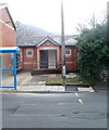
Public convenience, Ynysymaerdy Road, Briton Ferry
Public toilets located almost opposite the Community Hall. http://www.geograph.org.uk/photo/2309975
The facility was open and in good condition at the date of this photograph.
Image: © Jaggery
Taken: 19 Feb 2011
0.04 miles
5

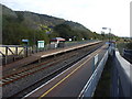
Briton Ferry Station
View northward, towards Neath and Swansea; ex-GWR South Wales main line, London/Bristol etc. - Cardiff - Swansea etc. This station, which itself was a replacement (8/7/35) of Briton Ferry West 600 yards south, was closed to passengers on 2/11/64, to goods on 6/9/65. However, another new station was later built a short distance to the north and opened on 1/6/94!
Image: © Ben Brooksbank
Taken: 1 Jun 1962
0.05 miles
6
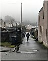
Walking along a back lane in Briton Ferry
Viewed across Rockingham Terrace on a murky, drizzly day in February 2024.
Image: © Jaggery
Taken: 14 Feb 2024
0.05 miles
7
Bilingual Rockingham Terrace name sign, Briton Ferry
Rockingham Terrace is Teras Rockingham in Welsh.
Image: © Jaggery
Taken: 14 Feb 2024
0.05 miles
8
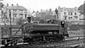
GW '6700' 0-6-0PT shunting at Briton Ferry
No. 6762 is one of the newer '6700' 0-6-0PTs. Built post-Nationalisation in 11/48, it lasted until 3/63. There were still extensive sidings at Briton Ferry in 1949.
Image: © Ben Brooksbank
Taken: 31 Aug 1949
0.05 miles
9
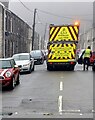
Your Recycling Crew At Work, Mansel Street, Briton Ferry
"YOUR RECYCLING CREW AT WORK" and the Welsh equivalent is on the back
of the lorry at work on a drizzly, misty day in February 2024.
Image: © Jaggery
Taken: 14 Feb 2024
0.05 miles
10
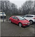
Briton Ferry railway station car park
On the west side of Rockingham Terrace.
Image: © Jaggery
Taken: 14 Feb 2024
0.06 miles