IMAGES TAKEN NEAR TO
Middleton Street, NEATH, SA11 2NU
Introduction
This page details the photographs taken nearby to Middleton Street, SA11 2NU by members of the Geograph project.
The Geograph project started in 2005 with the aim of publishing, organising and preserving representative images for every square kilometre of Great Britain, Ireland and the Isle of Man.

There are currently over 7.5m images from over14,400 individuals and you can help contribute to the project by visiting https://www.geograph.org.uk
Image Map (Loading...)


Getting Data...Please wait
Leaflet Map data © OpenStreetMap
Images are licensed for reuse under creativecommons.org/licenses/by-sa/2.0
Notes
- Clicking on the map will re-center to the selected point.
- The higher the marker number, the further away the image location is from the centre of the postcode.
Image Listing (56 Images Found)
Images are licensed for reuse under creativecommons.org/licenses/by-sa/2.0
Image
Details
Distance
1
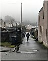
Walking along a back lane in Briton Ferry
Viewed across Rockingham Terrace on a murky, drizzly day in February 2024.
Image: © Jaggery
Taken: 14 Feb 2024
0.02 miles
2
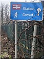
Station car park direction sign, Rockingham Terrace, Briton Ferry
The black arrow on the sign near the corner of Middleton Street points
towards Briton Ferry railway station car park. https://www.geograph.org.uk/photo/7709488 Gorsaf is Welsh for Station.
Image: © Jaggery
Taken: 14 Feb 2024
0.03 miles
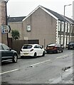
3
Junction of Middleton Street and Rockingham Terrace, Briton Ferry
From the left, Middleton Street joins Rockingham Terrace.
Image: © Jaggery
Taken: 14 Feb 2024
0.03 miles
4
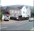
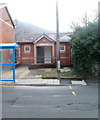
Ynysymaerdy Post Office, Briton Ferry
Dwarfed by adjacent housing, the post office is at 254 Neath Road (A474).
Image: © Jaggery
Taken: 19 Feb 2011
0.03 miles
5
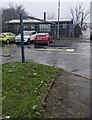
Station direction sign for walkers, Rockingham Terrace, Briton Ferry
The white arrow on the sign at the exit from the railway station car park
points north along Rockingham Terrace. Gorsaf is Welsh for Station.
Image: © Jaggery
Taken: 14 Feb 2024
0.03 miles
6

Briton Ferry Boxing Club poster
In February 2024 the poster on the door on the Rockingham Terrace side of
Briton Ferry Community Hall (on the left side of the hall here https://www.geograph.org.uk/photo/7709404 ) shows
that the club meets here from 6pm to 8pm on Mondays, Wednesdays and Fridays.
Image: © Jaggery
Taken: 14 Feb 2024
0.03 miles
7
Public convenience, Ynysymaerdy Road, Briton Ferry
Public toilets located almost opposite the Community Hall. http://www.geograph.org.uk/photo/2309975
The facility was open and in good condition at the date of this photograph.
Image: © Jaggery
Taken: 19 Feb 2011
0.04 miles
8

Wheelie bins awaiting emptying, Briton Ferry
At the northern end of Rockingham Terrace in February 2024.
Image: © Jaggery
Taken: 14 Feb 2024
0.04 miles
9
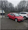
Briton Ferry railway station car park
On the west side of Rockingham Terrace.
Image: © Jaggery
Taken: 14 Feb 2024
0.04 miles
10
Metal frame at a car park entrance, Rockingham Terrace, Briton Ferry
The frame enforces a vehicle height limit.
Image: © Jaggery
Taken: 14 Feb 2024
0.04 miles