IMAGES TAKEN NEAR TO
Kennel Row, NEATH, SA11 2JE
Introduction
This page details the photographs taken nearby to Kennel Row, SA11 2JE by members of the Geograph project.
The Geograph project started in 2005 with the aim of publishing, organising and preserving representative images for every square kilometre of Great Britain, Ireland and the Isle of Man.

There are currently over 7.5m images from over14,400 individuals and you can help contribute to the project by visiting https://www.geograph.org.uk
Image Map
Images are licensed for reuse under creativecommons.org/licenses/by-sa/2.0
Notes
- Clicking on the map will re-center to the selected point.
- The higher the marker number, the further away the image location is from the centre of the postcode.
Image Listing (54 Images Found)
Images are licensed for reuse under creativecommons.org/licenses/by-sa/2.0
Image
Details
Distance
1
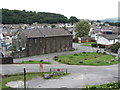
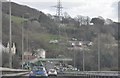
Bethesda Chapel, Briton Ferry
Looking down from the A48 flyover on to the former chapel, and stub of an old railway branch line.
Image: © Gareth James
Taken: 24 Aug 2014
0.02 miles
2
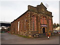
The Former Bethesda Chapel, Briton Ferry
Image: © Chris Andrews
Taken: 8 Mar 2022
0.03 miles
3

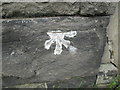
Ordnance Survey Cut Mark
This OS cut mark can be found on the north angle of the Bethesda Chapel. It marks a point 6.398m above mean sea level.
Image: © Adrian Dust
Taken: 2 Nov 2014
0.03 miles
4
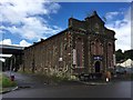
Aerobics and gym club
Former Chapel in Briton Ferry, now used as a centre for aerobics and gym.
Image: © Alan Hughes
Taken: 14 Sep 2017
0.03 miles
5
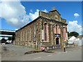
Capel Bethesda Chapel
Bethesda, Capel yr Annibynnwyr, Llansawel. Fe'i hadeiladwyd yn 1848 a chafodd ei ailadeiladu yn 1864. Aelod enwog o'r capel oedd yr emynydd, Mary Owen (1796-1875) o Ynysmaerdy. Caewyd yr addoldy yn 1989.
Bethesda Welsh Independent Chapel, Briton Ferry. First built in 1848 it was later rebuilt in 1864. A notable member was the hymnist, Mary Owen (1796-1875) of Ynysmaerdy. The chapel sadly closed in 1989.
Image: © Alan Richards
Taken: 6 Jul 2014
0.03 miles
6
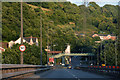
Briton Ferry : The A48
The A48 heading between Briton Ferry, Swansea and Port Talbot.
Image: © Lewis Clarke
Taken: 23 Mar 2014
0.03 miles
7
Ordnance Survey Cut Mark
This OS cut mark can be found on the east angle of the Bethesda Chapel. It marks a point 6.730m above mean sea level.
Image: © Adrian Dust
Taken: 2 Nov 2014
0.03 miles
8
Port Talbot : The A48
Heading towards Port Talbot on the A48 road.
Image: © Lewis Clarke
Taken: 23 Jul 2017
0.03 miles
9
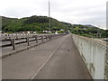
Wales Coast Path on the A48
Looking back towards Briton Ferry, the A48 bridge crosses the River Neath
Image: © Eirian Evans
Taken: 6 May 2019
0.04 miles
10
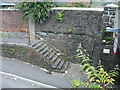
Stone steps. Church Street. Briton Ferry
Old stone steps in Church Street leading down to the subway under the railway between Church Street and Villiers Street.
Image: © Kevin Griffiths
Taken: 14 Jul 2011
0.06 miles