IMAGES TAKEN NEAR TO
Neath Road, NEATH, SA11 2DQ
Introduction
This page details the photographs taken nearby to Neath Road, SA11 2DQ by members of the Geograph project.
The Geograph project started in 2005 with the aim of publishing, organising and preserving representative images for every square kilometre of Great Britain, Ireland and the Isle of Man.

There are currently over 7.5m images from over14,400 individuals and you can help contribute to the project by visiting https://www.geograph.org.uk
Image Map (Loading...)


Getting Data...Please wait
Leaflet Map data © OpenStreetMap
Images are licensed for reuse under creativecommons.org/licenses/by-sa/2.0
Notes
- Clicking on the map will re-center to the selected point.
- The higher the marker number, the further away the image location is from the centre of the postcode.
Image Listing (48 Images Found)
Images are licensed for reuse under creativecommons.org/licenses/by-sa/2.0
Image
Details
Distance
5

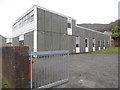
Briton Ferry Telephone Exchange (1)
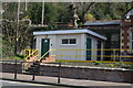
Situated in Hunter Street, this TE is of a common design dating from the early 1970s and has the code SWBPG. It provides telephone and broadband services to 5,958 residential and 193 non-residential premises in Briton Ferry plus Baglan nearby. A green BT cabinet can be seen on the pavement in front of this TE.
Image: © David Hillas
Taken: 13 Jan 2018
0.08 miles
6
Briton Ferry Telephone Exchange (2)
Situated in Hunter Street, this TE is of a standard design dating from the early 1970s, and is common throughout the United Kingdom. A grey metal gate can be seen in the foreground with a red rubbish bin behind it. The numbering ranges of this TE are (01639) 81xxxx, 82xxxx, the (01639) referring to the Neath group of eleven TEs, and its postcode is SA11 2RL.
Image: © David Hillas
Taken: 13 Jan 2018
0.09 miles
8
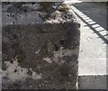
Ordnance Survey Cut Mark
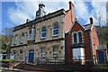
This OS cut mark can be found on the old Midland Bank. It marks a point 12.104m above mean sea level.
Image: © Adrian Dust
Taken: 5 Jun 2020
0.10 miles
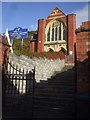
9
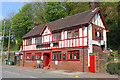
The Ferryman, Briton Ferry
The Ferryman public house, Briton Ferry.
Image: © Wayland Smith
Taken: 21 Apr 2014
0.13 miles
10
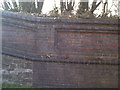
Railway retaining wall. Railway Terrace Briton Ferry
Detail of the railway retaining wall along Railway Terrace. The wall was built with a variety of materials, including red brick and blue engineering brick. Part of the lower part of the wall is brick and part is stone.
Image: © Kevin Griffiths
Taken: 14 Sep 2009
0.13 miles