IMAGES TAKEN NEAR TO
Neath Road, NEATH, SA11 2BX
Introduction
This page details the photographs taken nearby to Neath Road, SA11 2BX by members of the Geograph project.
The Geograph project started in 2005 with the aim of publishing, organising and preserving representative images for every square kilometre of Great Britain, Ireland and the Isle of Man.

There are currently over 7.5m images from over14,400 individuals and you can help contribute to the project by visiting https://www.geograph.org.uk
Image Map
Images are licensed for reuse under creativecommons.org/licenses/by-sa/2.0
Notes
- Clicking on the map will re-center to the selected point.
- The higher the marker number, the further away the image location is from the centre of the postcode.
Image Listing (67 Images Found)
Images are licensed for reuse under creativecommons.org/licenses/by-sa/2.0
Image
Details
Distance
1
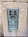
Ordnance Survey Flush Bracket (S1247)
This OS Flush Bracket can be found on the NE angle of St Clement's Church. It marks a point 8.617m above mean sea level.
Image: © Adrian Dust
Taken: 22 Mar 2014
0.01 miles
2
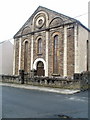
Former Salem Baptist Chapel, Briton Ferry
Located on Vernon Street, near the corner of Neath Road (A474).
Built in the 1870s, the chapel closed in 1971.
Image: © Jaggery
Taken: 19 Feb 2011
0.05 miles
3
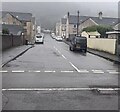
Caroline Street, Briton Ferry
Looking from Rockingham Terrace along Caroline Street towards Neath Road
on a murky, drizzly day in February 2024 when a tropical maritime airmass
covers southern Britain. On a clear day, a wooded hillside view would be
in the background.
Image: © Jaggery
Taken: 14 Feb 2024
0.07 miles
4
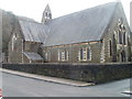
St Clement's church, Briton Ferry
Viewed across Grandison Street. The church is on the corner of Neath Road (A474).
The church board on the Neath Road side shows
The Church of St Clement of Rome, Briton Ferry, The Church in Wales, The Diocese of Llandaff.
Built in the 1860s, the church was Grade II listed in 2000.
Image: © Jaggery
Taken: 19 Feb 2011
0.08 miles
5
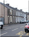
Hoo Street, Briton Ferry
Houses on the south side of Hoo Street view from the Neath Road (A474) end.
Image: © Jaggery
Taken: 19 Feb 2011
0.08 miles
6
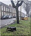
Tree stump on the west side of Rockingham Terrace, Briton Ferry
There are no houses on this side of the road.
Image: © Jaggery
Taken: 14 Feb 2024
0.10 miles
7
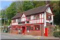
The Ferryman, Briton Ferry
The Ferryman public house, Briton Ferry.
Image: © Wayland Smith
Taken: 21 Apr 2014
0.10 miles
8
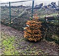
Brown Christmas tree, Rockingham Terrace, Briton Ferry
Viewed on February 14th 2024. Presumably the tree was dumped here in early January.
Image: © Jaggery
Taken: 14 Feb 2024
0.10 miles
9
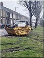
Yellow skip full of rubbish, Rockingham Terrace, Briton Ferry
On the west side of Rockingham Terrace in February 2024.
Image: © Jaggery
Taken: 14 Feb 2024
0.10 miles
10
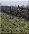
Logs behind a metal fence, Briton Ferry
On the railway side of the fence alongside Rockingham Terrace.
Image: © Jaggery
Taken: 14 Feb 2024
0.10 miles