IMAGES TAKEN NEAR TO
Crymlyn Gardens, NEATH, SA10 6EU
Introduction
This page details the photographs taken nearby to Crymlyn Gardens, SA10 6EU by members of the Geograph project.
The Geograph project started in 2005 with the aim of publishing, organising and preserving representative images for every square kilometre of Great Britain, Ireland and the Isle of Man.

There are currently over 7.5m images from over14,400 individuals and you can help contribute to the project by visiting https://www.geograph.org.uk
Image Map
Images are licensed for reuse under creativecommons.org/licenses/by-sa/2.0
Notes
- Clicking on the map will re-center to the selected point.
- The higher the marker number, the further away the image location is from the centre of the postcode.
Image Listing (32 Images Found)
Images are licensed for reuse under creativecommons.org/licenses/by-sa/2.0
Image
Details
Distance
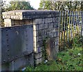
1

Ordnance Survey Cut Mark
This OS cut mark can be found on the milestone south side of the road. It marks a point 37.222m above mean sea level.
Image: © Adrian Dust
Taken: 22 Oct 2020
0.09 miles
2
Milestone - Swansea 5
On railway bridge south side of the road.
Milestone Society National ID: GLA_NTSW03
Image: © Adrian Dust
Taken: 22 Oct 2020
0.09 miles
3
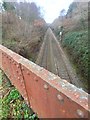
Railway bridge near Skewen
View of the Swansea District line near Skewen.
Image: © Alan Hughes
Taken: 21 Jan 2019
0.09 miles
4

Cefn yr Esgyrn, Sgiwen/ Skewen
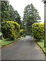
Llwybr cyhoeddus ar gefnen o'r enw Cefn yr Esgyrn o bosibl. Yn yr hen amser arweiniai'r heol at Ffarm Pen Twyn.
A public footpath on a ridge possibly known as Cefn yr Esgyrn. The path was formerly the access road to Pen Twyn Farm.
Image: © Alan Richards
Taken: 23 Apr 2013
0.09 miles
5
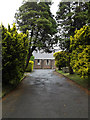
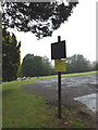
Coedffranc Cemetery entrance, Skewen
Looking towards the Coedffranc Cemetery Chapel
Image: © Geographer
Taken: 28 Jun 2015
0.12 miles

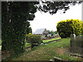
8
Coedffranc Cemetery entrance, Skewen
Looking towards Crymlyn Road
Image: © Geographer
Taken: 28 Jun 2015
0.13 miles
9

Railtour in the rain
A railtour for GCG heads west with the Llandarcy oil refinery in the background. 23rd April 1994. Details of this railtour below which operated over some freight only railway lines.
Monmouthshire Railway Society
Gwaun-cae-Gurwen Growler II
Locos Used 37258 & 37402
Route :
Loco Route
37258 (1) Newport - Lydney Groundframe
37402 (2) Lydney Groundframe - Norchard Low Level
37258 (1) Norchard Low Level - Lydney Groundframe
37402 (2) Lydney Groundframe - Newport - Aberthaw - Swansea District - Llandeilo Jn
37258 (1) Llandeilo Jn - Gwaun-cae-Gurwen
37402 (2) Gwaun-cae-Gurwen - Jersey Marine South Yard
37258 (1) Jersey Marine South Yard - Cwmgwrach
37402 (2) Cwmgwrach - Jersey Marine South Yard
37258 (1) Jersey Marine South Yard - Margam Yard - Tondu
37402 (2) Tondu - Llantrisant - Pengam
37258 (1) Pengam - Cardiff Docks (Texaco Terminal)
37402 (2) Cardiff Docks (Texaco Terminal) - Newport
Notes :
(1) 37402 on rear.
(2) 37258 on rear.
Image: © roger geach
Taken: 23 Apr 1994
0.13 miles
10
Coedffranc Cemetery car park
Off Crymlyn Road
Image: © Geographer
Taken: 28 Jun 2015
0.14 miles