IMAGES TAKEN NEAR TO
Stanley Road, SHEFFIELD, S8 9JB
Introduction
This page details the photographs taken nearby to Stanley Road, S8 9JB by members of the Geograph project.
The Geograph project started in 2005 with the aim of publishing, organising and preserving representative images for every square kilometre of Great Britain, Ireland and the Isle of Man.

There are currently over 7.5m images from over14,400 individuals and you can help contribute to the project by visiting https://www.geograph.org.uk
Image Map
Images are licensed for reuse under creativecommons.org/licenses/by-sa/2.0
Notes
- Clicking on the map will re-center to the selected point.
- The higher the marker number, the further away the image location is from the centre of the postcode.
Image Listing (43 Images Found)
Images are licensed for reuse under creativecommons.org/licenses/by-sa/2.0
Image
Details
Distance
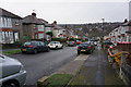
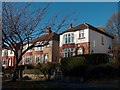
2
Raleigh Road towards Northcote Avenue, Sheffield
Image: © Ian S
Taken: 20 Jan 2018
0.11 miles
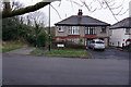
4
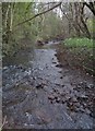
Meers Brook
Anciently, part of the border between Mercia and Northumbria. More recently, helping to divide Derbyshire from Yorkshire. Now, an unregarded stream.
Image: © Geoff
Taken: 31 Dec 2006
0.11 miles
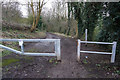
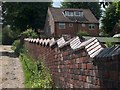
8
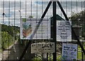
Allotment gates
Security conscious allotment holders at Heeley, Sheffield.
Image: © Peter Barr
Taken: 28 Aug 2010
0.14 miles
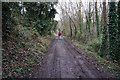
9
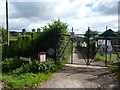
Allotment gates
Heeley & District Allotments, Carfield Lane, Sheffield. Sadly, even allotments need high security gates and barbed wire.
Image: © Peter Barr
Taken: 28 Aug 2010
0.14 miles