IMAGES TAKEN NEAR TO
Woodland View, BARNSLEY, S75 4RR
Introduction
This page details the photographs taken nearby to Woodland View, S75 4RR by members of the Geograph project.
The Geograph project started in 2005 with the aim of publishing, organising and preserving representative images for every square kilometre of Great Britain, Ireland and the Isle of Man.

There are currently over 7.5m images from over14,400 individuals and you can help contribute to the project by visiting https://www.geograph.org.uk
Image Map
Images are licensed for reuse under creativecommons.org/licenses/by-sa/2.0
Notes
- Clicking on the map will re-center to the selected point.
- The higher the marker number, the further away the image location is from the centre of the postcode.
Image Listing (74 Images Found)
Images are licensed for reuse under creativecommons.org/licenses/by-sa/2.0
Image
Details
Distance
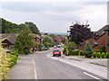
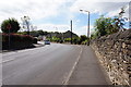
2
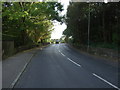
Knabbs Lane (B6449)
Heading south towards Oxspring.
Image: © JThomas
Taken: 3 Oct 2014
0.07 miles
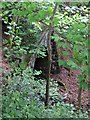
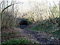
4
The mouth of the closed railway tunnel under Knabbs Lane at Silkstone
Image: © Martin Speck
Taken: 8 Aug 2010
0.07 miles
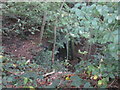
5

Pyracantha hedge
Not difficult to see why this is called firethorn!
Image: © Jonathan Thacker
Taken: 29 Sep 2017
0.07 miles
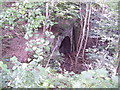
7
Looking down to the tunnel mouth
The east portal of the lower of the two Silkstone tunnels on the Wombwell to Silkstone West line. This was one of the steepest gradients on a British railway. The noise of four steam locomotives getting a loaded coal train up the bank to Penistone must have been terrific (and conditions in the tunnels appalling). The line was electrified for the last 30 years or so of its existence.
Image: © Jonathan Thacker
Taken: 29 Sep 2017
0.08 miles
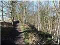
8
Eastern portal of the eastern tunnel
A well-used path leads to and through this tunnel, but the Trans Pennine Trail is on the edge of the cutting above.
Image: © Christine Johnstone
Taken: 2 Feb 2013
0.08 miles
9
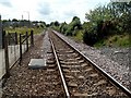
This Line for Penistone
From Silkstone Common Station.
Image: © John Fielding
Taken: 16 Jul 2007
0.08 miles
10
The 'Up and Over route'
The Trans Pennine and Dove Valley trails climbing up the edge of a former railway cutting, south of Silkstone Common.
Image: © Christine Johnstone
Taken: 2 Feb 2013
0.08 miles