IMAGES TAKEN NEAR TO
Taylor Hill, BARNSLEY, S75 4HB
Introduction
This page details the photographs taken nearby to Taylor Hill, S75 4HB by members of the Geograph project.
The Geograph project started in 2005 with the aim of publishing, organising and preserving representative images for every square kilometre of Great Britain, Ireland and the Isle of Man.

There are currently over 7.5m images from over14,400 individuals and you can help contribute to the project by visiting https://www.geograph.org.uk
Image Map (Loading...)


Getting Data...Please wait
Leaflet Map data © OpenStreetMap
Images are licensed for reuse under creativecommons.org/licenses/by-sa/2.0
Notes
- Clicking on the map will re-center to the selected point.
- The higher the marker number, the further away the image location is from the centre of the postcode.
Image Listing (64 Images Found)
Images are licensed for reuse under creativecommons.org/licenses/by-sa/2.0
Image
Details
Distance
1
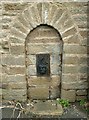
Have A Drink
A water pump on Taylor Hill Cawthorne, below the junction with Hill Top.
Image: © John Fielding
Taken: 26 Feb 2009
0.04 miles
2
Cawthorne Museum
The Museum is housed in a reconstructed building, first opened for Queen Victoria’s jubilee with exhibits of domestic bygones, Victoriana, memorabilia, natural history and local industries.
Image: © Nigel Homer
Taken: 26 Dec 2005
0.04 miles
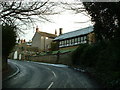
4
Cawthorne from Cannon Hall
The bridge over the pond giving access to Cannon Hall from Cawthorne is towards the bottom left of the view. Barnsley Hospital is on the skyline
Image: © Kevin Waterhouse
Taken: 30 Apr 2011
0.06 miles
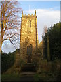
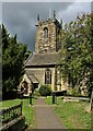
6
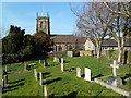
All Saints Church
The church is at the centre of one of this most picturesque village. Begun in the 17th century, it was restored in the 19th century.
Image: © Graham Hogg
Taken: 12 Mar 2012
0.07 miles
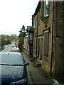
8
Old milestone
The road towards Shepley Lane Head and Holmfirth used to wend its way through Cawthorne village. In the 20C a by-pass was built. Some years ago this stone was found buried, perhaps from the 1940 Government instructions, but set up and in 2015 was repainted. Although set into the pavement all the legends can be read. The herb robert makes an attractive addition. It is Grade II listed 1151767.
Image: © Chris Minto
Taken: 12 Jun 2022
0.08 miles
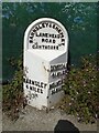
9
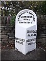
Old Milestone by Hill Top, Cawthorne
Metal plate attached to stone post by the UC road, in parish of CAWTHORNE (BARNSLEY District), Cawthorne village, in pavement next to Hill Top sign and near Bends sign, on North side of road. Brayshaw & Booth iron casting, erected by the County Council in the 19th century.
Inscription reads:-
: BARNSLEY / 4 MILES : : BARNSLEY & SHEPLEY / LANE HEAD / ROAD / CAWTHORNE : : DENBY DALE / 4¼ MILES / HOLMFIRTH / 10 MILES :
Hole in top.
Maker:-
: Brayshaw & Booth / Makers / Liversedge :
Grade II listed. List Entry Number: 1314694
https://historicengland.org.uk/listing/the-list/list-entry/1314694
Milestone Society National ID: YS_BNHF04.
Image: © C Minto
Taken: 1 Nov 2001
0.08 miles
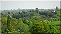
10
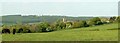
Hill House Farm to Cawthorne Church
The woodlands on the skyline are Cawthorne Park.
Image: © John Fielding
Taken: 3 May 2007
0.09 miles