IMAGES TAKEN NEAR TO
Calver Close, BARNSLEY, S75 3QW
Introduction
This page details the photographs taken nearby to Calver Close, S75 3QW by members of the Geograph project.
The Geograph project started in 2005 with the aim of publishing, organising and preserving representative images for every square kilometre of Great Britain, Ireland and the Isle of Man.

There are currently over 7.5m images from over14,400 individuals and you can help contribute to the project by visiting https://www.geograph.org.uk
Image Map
Images are licensed for reuse under creativecommons.org/licenses/by-sa/2.0
Notes
- Clicking on the map will re-center to the selected point.
- The higher the marker number, the further away the image location is from the centre of the postcode.
Image Listing (13 Images Found)
Images are licensed for reuse under creativecommons.org/licenses/by-sa/2.0
Image
Details
Distance
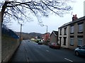
1
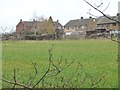
Houses on Rockingham Road, Gilroyd
The southern edge of the village, seen from the former railway line.
Image: © Christine Johnstone
Taken: 19 Mar 2016
0.11 miles
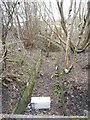
2
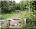
Sign to Wentworth Castle.
On the Trans Pennine Trail.
Image: © Steve Fareham
Taken: 2 Sep 2007
0.16 miles
3
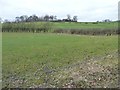
Farmland south of Intake Crescent, Gilroyd
Seen from the former railway line, now the Trans Pennine Trail. The houses amongst the trees on the horizon are on Intake Crescent.
Image: © Christine Johnstone
Taken: 19 Mar 2016
0.19 miles
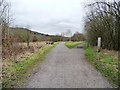
4
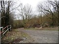
Track to Gilroyd Lane
Running south-east from the former railway line.
Image: © Christine Johnstone
Taken: 19 Mar 2016
0.20 miles
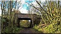
6
Fly-tipping near Strafford Industrial Park
This was a public footpath crossing under a railway line, but is now little used. The former railway line is now the Trans Pennine / Dove Valley Trail.
Image: © Christine Johnstone
Taken: 19 Mar 2016
0.22 miles
7
About 3 kms to Silkstone Common
Graffiti has covered the distance on the Trans Pennine Trail milepost. This path was built as a railway to Silkstone Moor End, and later became part of the electrified Woodhead line, closing in 1981.
Image: © Christine Johnstone
Taken: 19 Mar 2016
0.22 miles
8
Keresforth Road at Dodworth Bottom
Image: © Jonathan Clitheroe
Taken: 8 Feb 2017
0.24 miles
9
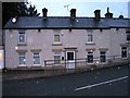
Children's nursery formerly Miners Inn
Image: © Alex McGregor
Taken: 14 Oct 2014
0.24 miles
10
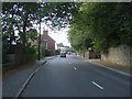
Keresforth Road (B6099), Dodworth Bottom
Heading west.
Image: © JThomas
Taken: 3 Oct 2014
0.24 miles