IMAGES TAKEN NEAR TO
Maple Court, BARNSLEY, S75 3DP
Introduction
This page details the photographs taken nearby to Maple Court, S75 3DP by members of the Geograph project.
The Geograph project started in 2005 with the aim of publishing, organising and preserving representative images for every square kilometre of Great Britain, Ireland and the Isle of Man.

There are currently over 7.5m images from over14,400 individuals and you can help contribute to the project by visiting https://www.geograph.org.uk
Image Map
Images are licensed for reuse under creativecommons.org/licenses/by-sa/2.0
Notes
- Clicking on the map will re-center to the selected point.
- The higher the marker number, the further away the image location is from the centre of the postcode.
Image Listing (5 Images Found)
Images are licensed for reuse under creativecommons.org/licenses/by-sa/2.0
Image
Details
Distance
2
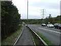
Path beside Westwood New Road (A61)
Heading south west towards Chapeltown.
Image: © JThomas
Taken: 27 Sep 2014
0.15 miles
3
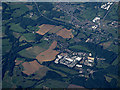
Upper Tankersley from the air
Industrial and business park near the M1 Junction 36 south of Barnsley.
Image: © Thomas Nugent
Taken: 6 Jul 2020
0.15 miles
4
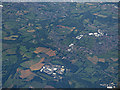
The M1 motorway from the air
Upper Tankersley is in the foreground, with Birdwell beyond and Hoyland on the right.
Image: © Thomas Nugent
Taken: 6 Jul 2020
0.23 miles
5

Tankersley Scales
Ministry of Transport roadside weighbridge by the A611 at Tankersley. As each axle of the vehicle under test rolls over the metal strip set into the road, its weight is displayed on the black panel above the window of the hut. This function is now controlled by VOSA - the Vehicle and Operator Safety Agency.
Image: © Roger May
Taken: 19 Nov 2005
0.24 miles