IMAGES TAKEN NEAR TO
Maple Road, BARNSLEY, S75 3DJ
Introduction
This page details the photographs taken nearby to Maple Road, S75 3DJ by members of the Geograph project.
The Geograph project started in 2005 with the aim of publishing, organising and preserving representative images for every square kilometre of Great Britain, Ireland and the Isle of Man.

There are currently over 7.5m images from over14,400 individuals and you can help contribute to the project by visiting https://www.geograph.org.uk
Image Map
Images are licensed for reuse under creativecommons.org/licenses/by-sa/2.0
Notes
- Clicking on the map will re-center to the selected point.
- The higher the marker number, the further away the image location is from the centre of the postcode.
Image Listing (20 Images Found)
Images are licensed for reuse under creativecommons.org/licenses/by-sa/2.0
Image
Details
Distance

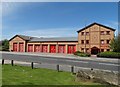
2
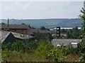
Tankersley Fire Station
Sited in the middle of the Industrial Estate on the site of the former Wharncliffe Silkstone Colliery.
Image: © Wendy North
Taken: 26 Jul 2008
0.09 miles
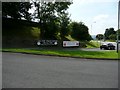
4
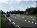
Entrance to Wentworth Industrial Estate
View south-west along the very busy A61. Tankersley Manor is just off to the left of the photograph.
Image: © Wendy North
Taken: 26 Jul 2008
0.10 miles
5
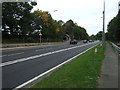
A61 Upper Tankersley
Heading north east towards Junction 36, M1 motorway.
Image: © JThomas
Taken: 27 Sep 2014
0.11 miles
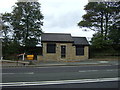
6

Tankersley Scales
Ministry of Transport roadside weighbridge by the A611 at Tankersley. As each axle of the vehicle under test rolls over the metal strip set into the road, its weight is displayed on the black panel above the window of the hut. This function is now controlled by VOSA - the Vehicle and Operator Safety Agency.
Image: © Roger May
Taken: 19 Nov 2005
0.11 miles
7
South Yorkshire Fire Station at Tankersley
Tankersley is a full time station providing fire cover to the residential areas of Hoyland, Birdwell, Wosborough, High Green and Chapeltown and also provides the first attendance to the smaller villages of Pilley, Tankersley, Wortley and Harley. Industrial and commercial areas covered include the Tankersley Platts Common and Chapeltown industrial estates. The station also provides the initial response to the M1, junctions 34-37, the A61 and the A616 Stocksbridge by-pass for road traffic collisions.
Image: © Neil Theasby
Taken: 11 May 2015
0.12 miles
8

Two of a kind
Post boxes in Tankersley Industrial Estate.
Image: © Steve Fareham
Taken: 20 May 2008
0.13 miles
9
Corner of Church Lane and Tankersley Manor
Forthcoming events at Tanksersley Manor.
Image: © Wendy North
Taken: 26 Jul 2008
0.16 miles
10

Temple of Trade
Jacquet UK is a service oriented stainless and nickel alloy processing company. Why they chose a mock-classical frontage to this functional commercial building is a mystery.
Image: © Neil Theasby
Taken: 11 May 2015
0.16 miles