IMAGES TAKEN NEAR TO
Shire Oak Drive, BARNSLEY, S74 8HU
Introduction
This page details the photographs taken nearby to Shire Oak Drive, S74 8HU by members of the Geograph project.
The Geograph project started in 2005 with the aim of publishing, organising and preserving representative images for every square kilometre of Great Britain, Ireland and the Isle of Man.

There are currently over 7.5m images from over14,400 individuals and you can help contribute to the project by visiting https://www.geograph.org.uk
Image Map (Loading...)


Getting Data...Please wait
Leaflet Map data © OpenStreetMap
Images are licensed for reuse under creativecommons.org/licenses/by-sa/2.0
Notes
- Clicking on the map will re-center to the selected point.
- The higher the marker number, the further away the image location is from the centre of the postcode.
Image Listing (46 Images Found)
Images are licensed for reuse under creativecommons.org/licenses/by-sa/2.0
Image
Details
Distance
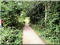
1
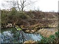
Holding the water up on the Elsecar Branch
A temporary dam, just east of Cobcar Bridge. The Elsecar Branch of the Dearne & Dove Canal was built to carry coal from local collieries. It had opened by 1798 and closed to traffic [due to mining subsidence] in 1928. It was officially closed in 1961. The towpath is well used by walkers and cyclists and a local group is keen to restore the canal.
Image: © Christine Johnstone
Taken: 5 Feb 2017
0.06 miles
2
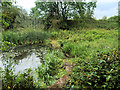
Elsecar Branch Canal between Elscar and Hemingfield
Prior to the arrival of the railway in the mid nineteenth century, the colliery and ironworks at Elsecar were served by a canal. The Dearne and Dove Canal ran for almost ten miles through South Yorkshire, from Swinton to Barnsley. The Elsecar branch opened in 1798 and closed in 1928. In 1991 the Barnsley Canal Group (reformed as the Barnsley, Dearne & Dove Canals Trust in 2000) commenced restoring the top of the Elsecar branch of the canal in 1991 conjunction with work at what is now the Elsecar Heritage Centre.
Image: © David Dixon
Taken: 20 Aug 2018
0.06 miles
3
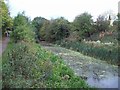
Disused Canal near Elsecar
Elsecar branch of the Dearne and Dove Canal which are both now disused. This picture was taken from the Barnsley Boundary Walk close to Wath Road.
Image: © Jonathan Clitheroe
Taken: 5 Oct 2011
0.06 miles
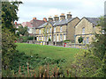
4
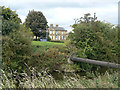
Across the canal
A pipe bridge crosses the remains of the Elsecar Canal. Beyond is part of an attractive terrace of miners cottages facing Wath Road. This is Cobcar Terrace, which is described in a Conservation Area report as follows:
On the corner of Cobcar Lane is Cobcar Terrace (162-180 Wath Road). Cobcar Terrace was an imposing and substantial later addition to the Fitzwilliam Estate with long front gardens running down to the road. This terrace dates from c1860 and is built in the same tradition as Station Row and Old Row (sixty years earlier). Like cottages of similar date, Cobcar Terrace is built of squared coursed and dressed sandstone with horizontal tooling marks and welsh slate roofing. It is remembered for the rhubarb which was grown in the front gardens, as the terrace is sometimes called ‘Rhubarb Row’. Cobcar Terrace is a two storey structure with an elegant double pedimented bay configuration. The front elevation is symmetrical with projecting gables flanking the central section. The gables include continuous stone gutters that continue behind the coping. Each gable has a fine cross glazed central window (oculus). The doors are vertically boarded with glazed overlights above the doorway. The windows in Cobcar Terrace are 16-pane sash windows with segmental-arched lintels above tooled to look like voussoirs.
Image: © Alan Murray-Rust
Taken: 13 Sep 2009
0.07 miles
5
Trans Pennine Trail near Elsecar
The path to the east of the Elsecar Branch Canal (between the canal and the railway) between Elsecar and Hemingfield.
Image: © David Dixon
Taken: 20 Aug 2018
0.07 miles
6
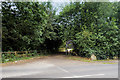
Trans Pennine Trail/Elsecar Greenway, Cobcar Bridge
Image: © David Dixon
Taken: 20 Aug 2018
0.07 miles
7
1-9 Cobcar Lane
There are a number of blocks with these pediment gables, all built around 1850.
Image: © Alan Murray-Rust
Taken: 13 Sep 2009
0.07 miles
8
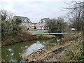
Gas main across the Elsecar Branch, Dearne & Dove Canal
At the site of Cobcar Lock. The new houses are off Shire Oaks Drive. This canal was built to carry coal from local collieries. It had opened by 1798 and closed to traffic [due to mining subsidence] in 1928. It was officially closed in 1961. The towpath is well used by walkers and cyclists and a local group is keen to restore the canal.
Image: © Christine Johnstone
Taken: 5 Feb 2017
0.08 miles
9
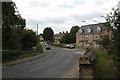
Wath Road, Elsecar
An interesting contrast between the new terrace in the foreground and the older houses beyond. The bridge crosses the disused canal.
Image: © Alan Murray-Rust
Taken: 13 Sep 2009
0.08 miles
10
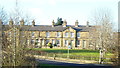
Row of cottages in Elsecar, South Yorkshire, affectionately known as "Rhubarb Row"
Image: © Jeff Pearson
Taken: 10 Dec 2012
0.08 miles