IMAGES TAKEN NEAR TO
Welland Crescent, BARNSLEY, S74 8AF
Introduction
This page details the photographs taken nearby to Welland Crescent, S74 8AF by members of the Geograph project.
The Geograph project started in 2005 with the aim of publishing, organising and preserving representative images for every square kilometre of Great Britain, Ireland and the Isle of Man.

There are currently over 7.5m images from over14,400 individuals and you can help contribute to the project by visiting https://www.geograph.org.uk
Image Map
Images are licensed for reuse under creativecommons.org/licenses/by-sa/2.0
Notes
- Clicking on the map will re-center to the selected point.
- The higher the marker number, the further away the image location is from the centre of the postcode.
Image Listing (21 Images Found)
Images are licensed for reuse under creativecommons.org/licenses/by-sa/2.0
Image
Details
Distance
1
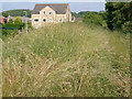
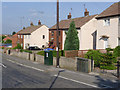
Overgrown footpath
The straight alignment of the footpath to the right of the picture is the result of it following the line of the old incline. Most people now probably use the new footpaths through the housing estate, marked by the lighting columns.
Image: © Alan Murray-Rust
Taken: 8 Jul 2013
0.10 miles
2
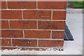
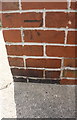
Benchmark on #48 Strafford Avenue
Ordnance Survey cut mark benchmark
Image: © Luke Shaw
Taken: 18 Aug 2018
0.13 miles
3
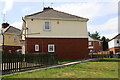
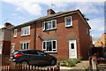
#48 Strafford Avenue
There is an OS benchmark Image on the right hand corner of the house under the house number
Image: © Luke Shaw
Taken: 18 Aug 2018
0.14 miles
4
Footpath and kissing gate
The edge of the housing estate on the north side of Elsecar.
Image: © Alan Murray-Rust
Taken: 8 Jul 2013
0.14 miles
5
Prefabricated houses on Wentworth Crescent
A small development of concrete slab prefabricated houses, probably from the immediate post-war period. Some of the houses have been 'improved' by having an outer skin of brick added.
Image: © Alan Murray-Rust
Taken: 8 Jul 2013
0.16 miles
7
Nos. 133 and 131 Strafford Avenue
There is an OS benchmark Image on the side of the right hand house near its front corner
Image: © Luke Shaw
Taken: 18 Aug 2018
0.17 miles
8
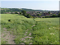
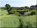
Footpath below Low Farm
Compared with its neighbour http://www.geograph.org.uk/photo/3549914 this path appears to be more heavily used and retains a more distinct line through the rape crop.
Image: © Alan Murray-Rust
Taken: 8 Jul 2013
0.18 miles
9
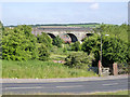
Jump Valley viaduct
Carrying the Midland Railway line from Sheffield to Barnsley. This was built as late as 1895 as an extension of the branch from Sheffield to Chapeltown, primarily to tap the coal traffic in the Barnsley area.
Image: © Alan Murray-Rust
Taken: 8 Jul 2013
0.19 miles
10
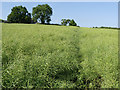
Footpath below Low Farm
Well-developed rape crops are never conducive to maintaining a good footpath.
Image: © Alan Murray-Rust
Taken: 8 Jul 2013
0.19 miles