IMAGES TAKEN NEAR TO
Leyfield Place, BARNSLEY, S73 8BF
Introduction
This page details the photographs taken nearby to Leyfield Place, S73 8BF by members of the Geograph project.
The Geograph project started in 2005 with the aim of publishing, organising and preserving representative images for every square kilometre of Great Britain, Ireland and the Isle of Man.

There are currently over 7.5m images from over14,400 individuals and you can help contribute to the project by visiting https://www.geograph.org.uk
Image Map
Images are licensed for reuse under creativecommons.org/licenses/by-sa/2.0
Notes
- Clicking on the map will re-center to the selected point.
- The higher the marker number, the further away the image location is from the centre of the postcode.
Image Listing (19 Images Found)
Images are licensed for reuse under creativecommons.org/licenses/by-sa/2.0
Image
Details
Distance
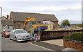
1
The site is still derelict 4 years since the 4x4 garage exploded
See Image
Image: © Steve Fareham
Taken: 16 Jan 2013
0.06 miles
2
Demolition of Temple Gym (former church).
Image: © Steve Fareham
Taken: 2 Sep 2007
0.06 miles
3
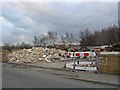
Total destruction
After a recent fire and explosion (16th December 2008) the remains of what was Total 4x4 garage on Pitt Street. Residents had to be evacuated.
Image: © Steve Fareham
Taken: 28 Dec 2008
0.07 miles
4
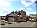
The Drop Public House, Darfield
Probably the last view of this public house before it is demolished.
Image: © Bill Henderson
Taken: 18 Mar 2012
0.09 miles
5
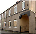
Derelict flats in a regeneration area.
This building used to be a shop and beer off.
Image: © Steve Fareham
Taken: 15 Aug 2007
0.10 miles
6
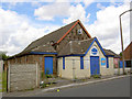
Temple Gym.
Now closed, formerly a church, notice damage to roof where lead has been stolen.
Another member stated on 30 September 2007: This old church has now been demolished.
Image: © Steve Fareham
Taken: 22 Jul 2007
0.11 miles
7
Low Valley traffic chaos
Traffic lights appear on Pitt Street.
Image: © Steve Fareham
Taken: 4 Feb 2011
0.13 miles
8
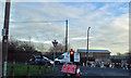
Low Valley roadworks
Junction of Pitt Street with George Street.
Image: © Steve Fareham
Taken: 19 Jan 2013
0.13 miles
9

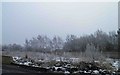
Allotment gardens - Low Valley
A view of the allotment gardens to the rear of Pit Street - Low Valley Darfield. The roof of the old snooker club is just visible to the far left of the picture.
Image: © Jeff Pearson
Taken: 5 May 2007
0.15 miles
10

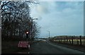
Gate off Pitt Street Low Valley
On this site in the 1920's were York Cottages. The area is now parkland on the reclaimed Darfield Main colliery site.
Image: © Steve Fareham
Taken: 5 Jan 2010
0.16 miles