IMAGES TAKEN NEAR TO
Holts View, SHEFFIELD, S7 2AE
Introduction
This page details the photographs taken nearby to Holts View, S7 2AE by members of the Geograph project.
The Geograph project started in 2005 with the aim of publishing, organising and preserving representative images for every square kilometre of Great Britain, Ireland and the Isle of Man.

There are currently over 7.5m images from over14,400 individuals and you can help contribute to the project by visiting https://www.geograph.org.uk
Image Map
Images are licensed for reuse under creativecommons.org/licenses/by-sa/2.0
Notes
- Clicking on the map will re-center to the selected point.
- The higher the marker number, the further away the image location is from the centre of the postcode.
Image Listing (38 Images Found)
Images are licensed for reuse under creativecommons.org/licenses/by-sa/2.0
Image
Details
Distance
1
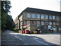
Former Abbeydale Grange Upper School
Now Abbeydale college.
Image: © Simon Fidler
Taken: 24 Aug 2003
0.03 miles
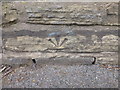
2
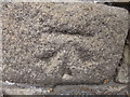
Cut Mark Abbeydale Road opposite Tesco's Petrol Station
Image: © Monica Stagg
Taken: 19 Apr 2015
0.07 miles
3
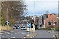
Tesco's Junction on the A621 Abbeydale Road, Sheffield
This signalised junction on the A621 Abbeydale Road was constructed specifically to serve Tesco supermarket.
Image: © Andrew Tryon
Taken: 21 Dec 2014
0.09 miles
4
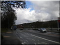
Tesco access road junction, Millhouses
This is where the access road to the Tesco supermarket in Millhouses leaves Abbeydale Road South. The end of Holt House Grove is visible on the left.
Image: © Richard Vince
Taken: 27 Apr 2013
0.10 miles
5
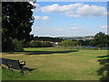
Abbeydale Grange Playing Fields
View of Carter Knowle area of Sheffield.
Image: © Simon Fidler
Taken: 24 Aug 2003
0.12 miles
6
Cut Mark Abbeydale Road opposite No 929
Image: © Monica Stagg
Taken: 19 Apr 2015
0.13 miles
7
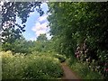
Carterknowle Park
This pocket park is really little more than a footpath linking Carterknowle Road and Abbeydale Road
Image: © Graham Hogg
Taken: 22 May 2020
0.14 miles
8
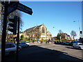
Junction of Bannerdale Road and Abbeydale Road
Image: © Peter Barr
Taken: 30 Jan 2010
0.14 miles
9
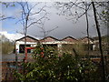
Former locomotive shed, Millhouses
Though apparently unused for some time, the shed at the Midland Railway's Millhouses depot still stands. This picture was taken from near the north eastern end of the Tesco car park, which (judging by a photo I have of the depot when it was open) was built on part of the shed site.
Image: © Richard Vince
Taken: 27 Apr 2013
0.14 miles
10

Bus turning circle, Tesco, Millhouses
The far north eastern end of the Tesco car park in Millhouses is designated a park and ride site, though judging by the quantity of vehicles in it on this Saturday afternoon it is not a particularly successful one. This is perhaps not surprising, given that the bus route that serves the site reaches Sheffield city centre via a rather indirect route; direct buses into town are a bit of a walk away on Abbeydale Road South. For some reason, the buses that terminate here lay over in the car park rather than in the bus turning circle. The supermarket itself is a fairly lengthy walk through the car park from the substantial bus shelter.
Image: © Richard Vince
Taken: 27 Apr 2013
0.14 miles