IMAGES TAKEN NEAR TO
Midland Road, BARNSLEY, S71 4DR
Introduction
This page details the photographs taken nearby to Midland Road, S71 4DR by members of the Geograph project.
The Geograph project started in 2005 with the aim of publishing, organising and preserving representative images for every square kilometre of Great Britain, Ireland and the Isle of Man.

There are currently over 7.5m images from over14,400 individuals and you can help contribute to the project by visiting https://www.geograph.org.uk
Image Map
Images are licensed for reuse under creativecommons.org/licenses/by-sa/2.0
Notes
- Clicking on the map will re-center to the selected point.
- The higher the marker number, the further away the image location is from the centre of the postcode.
Image Listing (42 Images Found)
Images are licensed for reuse under creativecommons.org/licenses/by-sa/2.0
Image
Details
Distance
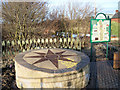
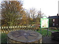
2

Compass rose
This marks the entry onto the Royston and Carlton Boundary Walk from the B6428 at Royston. At this point it is following the Trans Pennine Trail along the former Barnsley Canal.
Image: © Alan Murray-Rust
Taken: 20 May 2007
0.04 miles
3
Trans Pennine Trail marker Royston
Entrance to the Trans Pennine trail which follows the Barnsley Canal, this stretch of the canal from here to Walton is practically intact.
Image: © Steve Fareham
Taken: 2 Feb 2008
0.05 miles
4
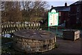
Compass and information board
The compass points to local features and places of interest. This is on the Trans Pennine Trail and also the Royston & Carlton boundary walk.
Image: © Graham Hogg
Taken: 30 Nov 2012
0.06 miles
5

The Barnsley Canal
Looking a bit dry.
Trans Pennine Trail runs beside it.
Image: © JThomas
Taken: 25 Sep 2013
0.06 miles
9

Barnsley Canal at Royston
The former Barnsley Canal at this point forms part of the Trans Pennine Trail. The Canal was built to serve coal mines in the barnsley area, but railways drained its profitability. It closed finally in 1954.
Image: © Alan Murray-Rust
Taken: 20 May 2007
0.07 miles