IMAGES TAKEN NEAR TO
Elmsdale, BARNSLEY, S70 5DL
Introduction
This page details the photographs taken nearby to Elmsdale, S70 5DL by members of the Geograph project.
The Geograph project started in 2005 with the aim of publishing, organising and preserving representative images for every square kilometre of Great Britain, Ireland and the Isle of Man.

There are currently over 7.5m images from over14,400 individuals and you can help contribute to the project by visiting https://www.geograph.org.uk
Image Map
Images are licensed for reuse under creativecommons.org/licenses/by-sa/2.0
Notes
- Clicking on the map will re-center to the selected point.
- The higher the marker number, the further away the image location is from the centre of the postcode.
Image Listing (22 Images Found)
Images are licensed for reuse under creativecommons.org/licenses/by-sa/2.0
Image
Details
Distance
1

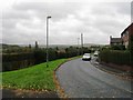
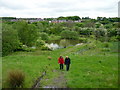
Open space between Elmsdale and Bridge Street
Seen from Glass House Crossing on the former railway line, skirting the southern edge of Worsbrough Dale.
Image: © Christine Johnstone
Taken: 19 Mar 2016
0.04 miles
2
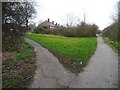
Footpath to Worsbrough Dale
Heading north off the Trans Pennine / Dove Valley Trail to a road called Elmsdale. The main path was built as a railway to Silkstone Moor End, and later became part of the electrified Woodhead line, closing in 1981.
Image: © Christine Johnstone
Taken: 19 Mar 2016
0.08 miles
4
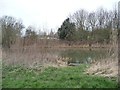
Fishing peg on the former Worsbrough branch
The 2.5 mile long Worsbrough section of the Dearne and Dove Canal opened in 1804. It linked Worsbrough to the seaport of Goole. The branch closed for navigation in 1906 and was abandoned in 1961.
Image: © Christine Johnstone
Taken: 19 Mar 2016
0.10 miles
6
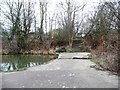
![The former Worsbrough branch canal [lower level]](https://s3.geograph.org.uk/geophotos/04/87/38/4873863_3b9d4732_120x120.jpg)
The former Worsbrough branch canal [lower level]
Looking eastwards from the footbridge over the weir. The 2.5 mile long Worsbrough section of the Dearne and Dove Canal opened in 1804. It linked Worsbrough to the seaport of Goole. The branch closed for navigation in 1906 and was abandoned in 1961.
Image: © Christine Johnstone
Taken: 19 Mar 2016
0.10 miles
8
Footpath across the former Worsbrough branch canal
Created over a weir long after the canal fell out of use. The 2.5 mile long Worsbrough section of the Dearne and Dove Canal opened in 1804. It linked Worsbrough to the seaport of Goole. The branch closed for navigation in 1906 and was abandoned in 1961.
Image: © Christine Johnstone
Taken: 19 Mar 2016
0.11 miles
9
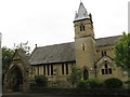
Worsbrough Church
The Catholic church in Worsbrough serving Worsbrough, Kendray and Ardsley
Image: © trevor willis
Taken: 21 Jun 2008
0.12 miles