IMAGES TAKEN NEAR TO
Ravenholt, BARNSLEY, S70 5DF
Introduction
This page details the photographs taken nearby to Ravenholt, S70 5DF by members of the Geograph project.
The Geograph project started in 2005 with the aim of publishing, organising and preserving representative images for every square kilometre of Great Britain, Ireland and the Isle of Man.

There are currently over 7.5m images from over14,400 individuals and you can help contribute to the project by visiting https://www.geograph.org.uk
Image Map
Images are licensed for reuse under creativecommons.org/licenses/by-sa/2.0
Notes
- Clicking on the map will re-center to the selected point.
- The higher the marker number, the further away the image location is from the centre of the postcode.
Image Listing (33 Images Found)
Images are licensed for reuse under creativecommons.org/licenses/by-sa/2.0
Image
Details
Distance
1
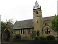
Worsbrough Church
The Catholic church in Worsbrough serving Worsbrough, Kendray and Ardsley
Image: © trevor willis
Taken: 21 Jun 2008
0.07 miles
2
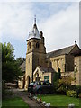
Catholic Church in Worsbrough
Dedicated to Our Lady and St James in the Diocese of Hallam.
Image: © Neil Theasby
Taken: 21 Sep 2014
0.08 miles
3

Worsbrough - Roman Catholic Church
Dedicated to "Our Lady and Saint James".
Image: © Dave Bevis
Taken: 3 May 2014
0.09 miles
6
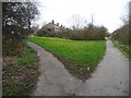
Footpath to Worsbrough Dale
Heading north off the Trans Pennine / Dove Valley Trail to a road called Elmsdale. The main path was built as a railway to Silkstone Moor End, and later became part of the electrified Woodhead line, closing in 1981.
Image: © Christine Johnstone
Taken: 19 Mar 2016
0.10 miles
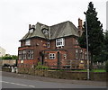
7
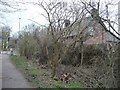
Former crossing keeper's cottage, Worsbrough Bridge
Seen from the former railway, immediately east of Bridge Crossing on the A61. This path was built as a railway to Silkstone Moor End, and later became part of the electrified Woodhead line, closing in 1981.
Image: © Christine Johnstone
Taken: 19 Mar 2016
0.10 miles
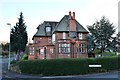
8

Worsbrough - Mogul Room
For a view of this restaurant in its 2012 colour scheme, please see Image
Image: © Dave Bevis
Taken: 3 May 2014
0.11 miles