IMAGES TAKEN NEAR TO
East Vale Drive, ROTHERHAM, S65 4HS
Introduction
This page details the photographs taken nearby to East Vale Drive, S65 4HS by members of the Geograph project.
The Geograph project started in 2005 with the aim of publishing, organising and preserving representative images for every square kilometre of Great Britain, Ireland and the Isle of Man.

There are currently over 7.5m images from over14,400 individuals and you can help contribute to the project by visiting https://www.geograph.org.uk
Image Map
Images are licensed for reuse under creativecommons.org/licenses/by-sa/2.0
Notes
- Clicking on the map will re-center to the selected point.
- The higher the marker number, the further away the image location is from the centre of the postcode.
Image Listing (13 Images Found)
Images are licensed for reuse under creativecommons.org/licenses/by-sa/2.0
Image
Details
Distance
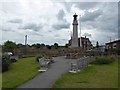
2
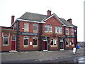
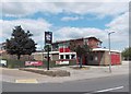
Thrybergh - War Memorial and The Fullerton
The pub is an imposing building in semi-classical style and clearly dates from the expansion of Thrybergh as residential area for local steelworkers and miners.
Image: © Alan Murray-Rust
Taken: 16 Dec 2007
0.18 miles
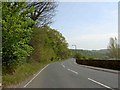
4
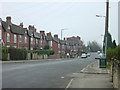
Park Lane, Thrybergh
This is the main road through the older part of the industrial era development of Thrybergh. The main Doncaster Road between Rotherham and Conisbrough skirts it to the west so that this thoroughfare remains remarkably peaceful.
Image: © Alan Murray-Rust
Taken: 16 Dec 2007
0.19 miles
5
"The Reresby Arms" public house in Thrybergh
"Reresby" is the correct spelling and not "Rearsby" on any other variation. The regulars are most particular about spelling.
Image: © Neil Theasby
Taken: 25 Jun 2013
0.19 miles
6
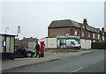
Posting for Christmas.
The lady has just posted a large handful of cards in the pillar box. Note the fine advert for Bentley's Beers on the side of the house.
Image: © Alan Murray-Rust
Taken: 16 Dec 2007
0.19 miles
7
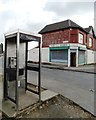
Welcome to Thrybergh
The phonebox has been vandalised and the corner shop - though open for business still has its shutters down.
Image: © Neil Theasby
Taken: 24 Apr 2014
0.19 miles
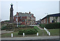
10
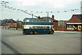
British Trolleybuses - Rotherham
When I visited Rotherham there was only one trolleybus route remaining, running from Kimberworth to Thrybergh; it only had a few more months to live. This is the terminus at Thrybergh where the trolleybuses turned in the junction of Park Road and Vale Road.
For a slide show of British Trolleybuses in the late 60s http://www.geograph.org.uk/search.php?i=1773236&displayclass=slide
Image: © Alan Murray-Rust
Taken: 4 Apr 1965
0.21 miles