IMAGES TAKEN NEAR TO
Wildene Drive, MEXBOROUGH, S64 9SN
Introduction
This page details the photographs taken nearby to Wildene Drive, S64 9SN by members of the Geograph project.
The Geograph project started in 2005 with the aim of publishing, organising and preserving representative images for every square kilometre of Great Britain, Ireland and the Isle of Man.

There are currently over 7.5m images from over14,400 individuals and you can help contribute to the project by visiting https://www.geograph.org.uk
Image Map (Loading...)


Getting Data...Please wait
Leaflet Map data © OpenStreetMap
Images are licensed for reuse under creativecommons.org/licenses/by-sa/2.0
Notes
- Clicking on the map will re-center to the selected point.
- The higher the marker number, the further away the image location is from the centre of the postcode.
Image Listing (6 Images Found)
Images are licensed for reuse under creativecommons.org/licenses/by-sa/2.0
Image
Details
Distance
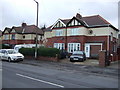
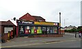
3
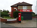
Takeaway on Adwick Road
Showing position of Postbox No. S64 102.
Image: © JThomas
Taken: 19 Sep 2022
0.22 miles
4
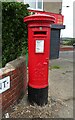
George VI postbox on Adwick Road
Postbox No. S64 227.
Image: © JThomas
Taken: 19 Sep 2022
0.22 miles
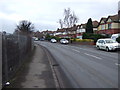
6
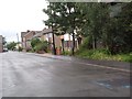
Kirby Street, Mexborough
As part of a programme of housing improvement to deal with long-standing social problems in the area, the Office of the Deputy Prime Minister chose to fund the demolition and rebuilding of Kirby Street. By July 2007, most inhabitants had moved out and certain building materials had been crudely removed by persons unknown, leaving the scene shown here.
Image: © David Wilkinson
Taken: 13 Jul 2007
0.24 miles