IMAGES TAKEN NEAR TO
Kelvin Street, MEXBOROUGH, S64 9BH
Introduction
This page details the photographs taken nearby to Kelvin Street, S64 9BH by members of the Geograph project.
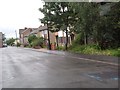
The Geograph project started in 2005 with the aim of publishing, organising and preserving representative images for every square kilometre of Great Britain, Ireland and the Isle of Man.

There are currently over 7.5m images from over14,400 individuals and you can help contribute to the project by visiting https://www.geograph.org.uk
Image Map
Images are licensed for reuse under creativecommons.org/licenses/by-sa/2.0
Notes
- Clicking on the map will re-center to the selected point.
- The higher the marker number, the further away the image location is from the centre of the postcode.
Image Listing (20 Images Found)
Images are licensed for reuse under creativecommons.org/licenses/by-sa/2.0
Image
Details
Distance
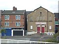
1
Ginnel in Mexborough
A ginnel in Mexborough.
Image: © Dave Pickersgill
Taken: 9 Apr 2015
0.14 miles
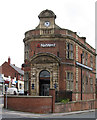
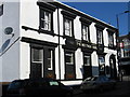
3
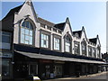
Mexborough - Billiard Rooms
On Garden Street.
Image: © Dave Bevis
Taken: 8 Apr 2010
0.17 miles
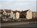
4
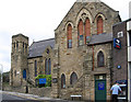
Primitive Motorist Chapel
These shops stand in Bank Street opposite the flyover bringing traffic into Mexborough from the east via the A6023. Though partly effaced, the words "PRIMITIVE METHODIST CHAPEL" can be read above the name board of the shop on the right, indicating the building's former use.
Image: © David Wilkinson
Taken: 20 Sep 2007
0.17 miles
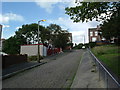
5
Kirby Street, Mexborough
As part of a programme of housing improvement to deal with long-standing social problems in the area, the Office of the Deputy Prime Minister chose to fund the demolition and rebuilding of Kirby Street. By July 2007, most inhabitants had moved out and certain building materials had been crudely removed by persons unknown, leaving the scene shown here.
Image: © David Wilkinson
Taken: 13 Jul 2007
0.17 miles
7
Belle Vue Road, Mexborough
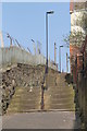
This is the town's one remaining cobbled street. Mexborough is built on the north bank of the River Don and the steep slope of this and nearby streets is the result. The houses visible are typical of terraced properties in the area and date from the 1890s to the early 1920s.
Image: © David Wilkinson
Taken: 22 Aug 2004
0.19 miles
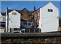
10
The rear of the Montagu Arms, Mexborough
Image: © Jonathan Thacker
Taken: 3 Jan 2019
0.21 miles