IMAGES TAKEN NEAR TO
Tiverton Close, MEXBOROUGH, S64 8TL
Introduction
This page details the photographs taken nearby to Tiverton Close, S64 8TL by members of the Geograph project.
The Geograph project started in 2005 with the aim of publishing, organising and preserving representative images for every square kilometre of Great Britain, Ireland and the Isle of Man.

There are currently over 7.5m images from over14,400 individuals and you can help contribute to the project by visiting https://www.geograph.org.uk
Image Map
Images are licensed for reuse under creativecommons.org/licenses/by-sa/2.0
Notes
- Clicking on the map will re-center to the selected point.
- The higher the marker number, the further away the image location is from the centre of the postcode.
Image Listing (9 Images Found)
Images are licensed for reuse under creativecommons.org/licenses/by-sa/2.0
Image
Details
Distance
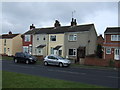
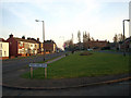
2
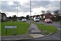
Lime Grove/Muirfield Avenue junction, Swinton
Image: © Neil Theasby
Taken: 5 Dec 2012
0.19 miles
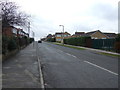
4
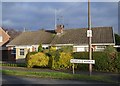
Semi-detached bungalow, Muirfield Avenue, Swinton
Several of the streets in this area of Swinton are, perhaps rather incongruously, named after golf courses.
Image: © Neil Theasby
Taken: 5 Dec 2012
0.20 miles
8
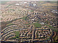
Wentworth Parks Estate
Almost all of the estate showing Celandine Rise from left to right the road drops steeply but cannot be seen from the air photo, middle right standing out well is the playing field of Saint Thomas junior & infant school, upper right shows the LNER railway, canal & river Don all close together.
Image: © Mick Kaye
Taken: Unknown
0.25 miles
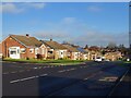
9
Manor Farm Drive Swinton
The next right turn is Piccadilly.
Image: © Steve Fareham
Taken: 10 Feb 2008
0.25 miles