IMAGES TAKEN NEAR TO
Low Wood Close, MEXBOROUGH, S64 8EH
Introduction
This page details the photographs taken nearby to Low Wood Close, S64 8EH by members of the Geograph project.
The Geograph project started in 2005 with the aim of publishing, organising and preserving representative images for every square kilometre of Great Britain, Ireland and the Isle of Man.

There are currently over 7.5m images from over14,400 individuals and you can help contribute to the project by visiting https://www.geograph.org.uk
Image Map
Images are licensed for reuse under creativecommons.org/licenses/by-sa/2.0
Notes
- Clicking on the map will re-center to the selected point.
- The higher the marker number, the further away the image location is from the centre of the postcode.
Image Listing (3 Images Found)
Images are licensed for reuse under creativecommons.org/licenses/by-sa/2.0
Image
Details
Distance
1
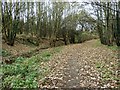
Woodland at Swinton
Woodland path in the Piccadilly area of Swinton.
Image: © Jonathan Clitheroe
Taken: 23 Nov 2015
0.11 miles
2
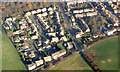
The Hamlet of Piccadilly
This photo was taken from 1000 feet AGL, centre right is the pub High House on the B6090 showing the "T" junction with Piccadilly Road.
Image: © Mick Kaye
Taken: Unknown
0.19 miles