IMAGES TAKEN NEAR TO
Twigg Court, MEXBOROUGH, S64 5WA
Introduction
This page details the photographs taken nearby to Twigg Court, S64 5WA by members of the Geograph project.
The Geograph project started in 2005 with the aim of publishing, organising and preserving representative images for every square kilometre of Great Britain, Ireland and the Isle of Man.

There are currently over 7.5m images from over14,400 individuals and you can help contribute to the project by visiting https://www.geograph.org.uk
Image Map
Images are licensed for reuse under creativecommons.org/licenses/by-sa/2.0
Notes
- Clicking on the map will re-center to the selected point.
- The higher the marker number, the further away the image location is from the centre of the postcode.
Image Listing (15 Images Found)
Images are licensed for reuse under creativecommons.org/licenses/by-sa/2.0
Image
Details
Distance
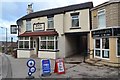
1
Houses on Newsam Road, Swinton, Yorkshire
Taken from the Sheffield bound train.
Image: © Ian S
Taken: 3 May 2014
0.14 miles
2
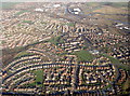
Wentworth Parks Estate
Almost all of the estate showing Celandine Rise from left to right the road drops steeply but cannot be seen from the air photo, middle right standing out well is the playing field of Saint Thomas junior & infant school, upper right shows the LNER railway, canal & river Don all close together.
Image: © Mick Kaye
Taken: Unknown
0.16 miles
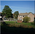
4
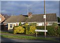
Semi-detached bungalow, Muirfield Avenue, Swinton
Several of the streets in this area of Swinton are, perhaps rather incongruously, named after golf courses.
Image: © Neil Theasby
Taken: 5 Dec 2012
0.18 miles
5
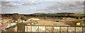
Former Croda site near Swinton
Another part of the site shown in Image The blurred metal parapet in the foreground is part of the railway bridge crossing Carlisle Road, which can be seen on the left approaching its bridge over the Sheffield and South Yorkshire Navigation, itself visible.
Work is taking place to prepare the polluted site for housing http://www.southyorkshiretimes.co.uk/news/business/cash-set-aside-for-homes-bid-1-5195229 .
Image: © Derek Harper
Taken: 4 Apr 2013
0.18 miles
6
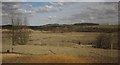
Former Croda site near Swinton
A view from the railway line south of Swinton station. This part of the site, bordered on the far side by the Sheffield and South Yorkshire Navigation, was used by Croda for coal tar distillation and bitument manufacture. A detailed account of the state of the site in August 2011 is at http://roam.rotherham.gov.uk/PlanNet/documentstore%5CGY%20AND%20GROUND%20CONDITIONS_01_1.PDF . Controversally, housing is planned.
Image: © Derek Harper
Taken: 4 Apr 2013
0.20 miles
7
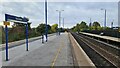
Swinton station
Three platforms on the 1990 station after rail services restored following closure of the previous station in 1968.
Image: © Chris Morgan
Taken: 19 Oct 2022
0.23 miles
8
Footpath Nr Swinton
Not much of a view.
Image: © roger geach
Taken: 21 Apr 2012
0.23 miles