IMAGES TAKEN NEAR TO
Pastures Bridge, Doncaster Road, MEXBOROUGH, S64 0JF
Introduction
This page details the photographs taken nearby to Pastures Bridge, Doncaster Road, S64 0JF by members of the Geograph project.
The Geograph project started in 2005 with the aim of publishing, organising and preserving representative images for every square kilometre of Great Britain, Ireland and the Isle of Man.

There are currently over 7.5m images from over14,400 individuals and you can help contribute to the project by visiting https://www.geograph.org.uk
Image Map
Images are licensed for reuse under creativecommons.org/licenses/by-sa/2.0
Notes
- Clicking on the map will re-center to the selected point.
- The higher the marker number, the further away the image location is from the centre of the postcode.
Image Listing (44 Images Found)
Images are licensed for reuse under creativecommons.org/licenses/by-sa/2.0
Image
Details
Distance
1
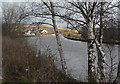
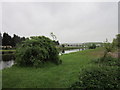
Sheffield and South Yorkshire Navigation
Looking east from the site of Pasture Bridge, near Mexborough.
Image: © Alan Murray-Rust
Taken: 10 Feb 2010
0.03 miles

3
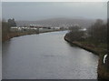
What a difference a few minutes can make (1)
The Sheffield and South Yorkshire Navigation at Denaby Main taken during a flurry of snow. 30 minutes later this view looked like this http://www.geograph.org.uk/photo/1731001 .
Image: © Alan Murray-Rust
Taken: 10 Feb 2010
0.05 miles
4
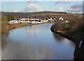
What a difference a few minutes can make (2)
Compare this blissful sunny view of the Sheffield and South Yorkshire Navigation with this one http://www.geograph.org.uk/photo/1730881 taken just 30 minutes previously.
Image: © Alan Murray-Rust
Taken: 10 Feb 2010
0.05 miles
5
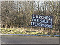
Lurches for sale
Further examination shows that this relates in fact to lurcher pups.
Image: © Alan Murray-Rust
Taken: 10 Feb 2010
0.05 miles
7
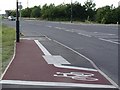
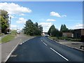
Mexborough's shortest cycle lane
We're always being told that, to reduce climate change, for short journeys we should consider cycling instead of driving. Well, here is a cycle lane for VERY short journeys, at the north end of Bambury Bridge on the A6023 on the eastern outskirts of Mexborough.
The original route of the A6023 followed the turning visible at the far right of this photo across a lower-lying bridge - often subject to flooding - over the River Don, and a level crossing. Bambury Bridge opened in 2001.
Image: © David Wilkinson
Taken: 10 Jun 2004
0.05 miles
8
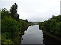
The Mexborough New Cut / South Yorkshire Navigation
Image: © JThomas
Taken: 19 Sep 2022
0.07 miles
9
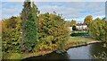
Sewage Pumping station
Well hidden by trees
Image: © Chris Morgan
Taken: 19 Oct 2022
0.07 miles