IMAGES TAKEN NEAR TO
Utleys Croft, ROTHERHAM, S63 6FT
Introduction
This page details the photographs taken nearby to Utleys Croft, S63 6FT by members of the Geograph project.
The Geograph project started in 2005 with the aim of publishing, organising and preserving representative images for every square kilometre of Great Britain, Ireland and the Isle of Man.

There are currently over 7.5m images from over14,400 individuals and you can help contribute to the project by visiting https://www.geograph.org.uk
Image Map
Images are licensed for reuse under creativecommons.org/licenses/by-sa/2.0
Notes
- Clicking on the map will re-center to the selected point.
- The higher the marker number, the further away the image location is from the centre of the postcode.
Image Listing (14 Images Found)
Images are licensed for reuse under creativecommons.org/licenses/by-sa/2.0
Image
Details
Distance

2
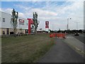
KFC on Manvers Way
One of many new buildings in this former industrial area.
Image: © Steve Fareham
Taken: 31 Jul 2011
0.11 miles
3

West Melton
Looking eastwards from West Melton, South Yorkshire, towards Wath upon Dearne Church.
Image: © Martin Clark
Taken: Unknown
0.16 miles
4

Electricity Pylon
Overhead electricity transmission lines cut across a housing estate in West Melton leaving a house on Burns Way with a pylon practically in the garden.
Image: © Siobhan Brennan-Raymond
Taken: 11 Nov 2012
0.18 miles
5
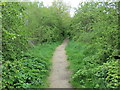
Woodland path that follows the line of the long disused Dearne & Dove Canal between Wath and Wombwell
Looking north-westward in the direction of Wombwell.
Image: © Peter Wood
Taken: 4 May 2018
0.18 miles
6

Burns Way
1950s council houses in West Melton.
Image: © Burgess Von Thunen
Taken: 27 Feb 2013
0.19 miles
7
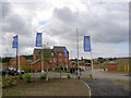
New homes by Ben Bailey.
Ben Bailey recently acquired by Gladedale.
Image: © Steve Fareham
Taken: 17 Aug 2007
0.20 miles
8
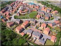
Wentworth Grange Estate
The housing estate is part of the Manvers development at Wath-upon-Dearne. This site was un-developed wetland until the 2000s.
Image: © Christopher Thomas
Taken: 17 Jul 2012
0.21 miles
9
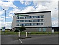
"Holiday Inn Express" Hotel by Manvers Way
Image: © Neil Theasby
Taken: 14 Jul 2016
0.21 miles
10
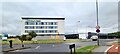
Holiday Inn Express, Wath upon Dearne
Previously marketed as Rotherham North, and peaceful Aldi, built on former site of Manvers colliery and railway marshalling yards.
The hotel in a somewhat damaged condition after being the centre of a recent violent siege by anti-immigration 'protesters.'
Image: © Chris Morgan
Taken: 2 Sep 2024
0.22 miles