IMAGES TAKEN NEAR TO
Munsbrough Lane, ROTHERHAM, S61 4NT
Introduction
This page details the photographs taken nearby to Munsbrough Lane, S61 4NT by members of the Geograph project.
The Geograph project started in 2005 with the aim of publishing, organising and preserving representative images for every square kilometre of Great Britain, Ireland and the Isle of Man.

There are currently over 7.5m images from over14,400 individuals and you can help contribute to the project by visiting https://www.geograph.org.uk
Image Map
Images are licensed for reuse under creativecommons.org/licenses/by-sa/2.0
Notes
- Clicking on the map will re-center to the selected point.
- The higher the marker number, the further away the image location is from the centre of the postcode.
Image Listing (5 Images Found)
Images are licensed for reuse under creativecommons.org/licenses/by-sa/2.0
Image
Details
Distance
1
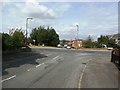
Crossroads in Greasbrough
Pictured from Munsbrough Lane.
Image: © Jonathan Clitheroe
Taken: 10 Aug 2016
0.07 miles
3
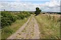
Above Munsbrough Lane
Looking northeast towards Munsbrough Lane from the bridleway to the southwest; the tower of Greasbrough church (Image) is visible in the distance to the far right.
Image: © Dave Dunford
Taken: 7 Jul 2007
0.23 miles
4
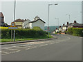
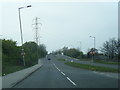
The entry to Greasbrough
The B6089 narrows from a dual carriageway and turns sharply downhill into Greasbrough
Image: © Alan Murray-Rust
Taken: 11 May 2008
0.23 miles
5
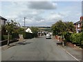
B6089 Car Hill at Barbot Hill Road junction
Image: © Colin Pyle
Taken: 7 Apr 2019
0.24 miles