IMAGES TAKEN NEAR TO
Broom Riddings, ROTHERHAM, S61 4NR
Introduction
This page details the photographs taken nearby to Broom Riddings, S61 4NR by members of the Geograph project.
The Geograph project started in 2005 with the aim of publishing, organising and preserving representative images for every square kilometre of Great Britain, Ireland and the Isle of Man.

There are currently over 7.5m images from over14,400 individuals and you can help contribute to the project by visiting https://www.geograph.org.uk
Image Map
Images are licensed for reuse under creativecommons.org/licenses/by-sa/2.0
Notes
- Clicking on the map will re-center to the selected point.
- The higher the marker number, the further away the image location is from the centre of the postcode.
Image Listing (5 Images Found)
Images are licensed for reuse under creativecommons.org/licenses/by-sa/2.0
Image
Details
Distance
1
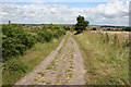
Above Munsbrough Lane
Looking northeast towards Munsbrough Lane from the bridleway to the southwest; the tower of Greasbrough church (Image) is visible in the distance to the far right.
Image: © Dave Dunford
Taken: 7 Jul 2007
0.06 miles
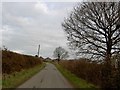
3
Telecoms mast from Bassingthorpe Lane
Image: © Steve Fareham
Taken: 17 Jan 2008
0.16 miles
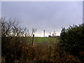
4
Mast between Greasbrough and Kimberworth Park
Sited on high ground between Greasbrough and Rotherham.
Image: © Dave Dunford
Taken: 7 Jul 2007
0.19 miles
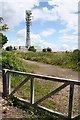
5
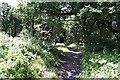
Woodland near Kimberworth Park
This woodland is open to the public via the "Rotherham's woodland estate" scheme.
Image: © Dave Dunford
Taken: 7 Jul 2007
0.25 miles