IMAGES TAKEN NEAR TO
Louden Road, ROTHERHAM, S61 2SU
Introduction
This page details the photographs taken nearby to Louden Road, S61 2SU by members of the Geograph project.
The Geograph project started in 2005 with the aim of publishing, organising and preserving representative images for every square kilometre of Great Britain, Ireland and the Isle of Man.

There are currently over 7.5m images from over14,400 individuals and you can help contribute to the project by visiting https://www.geograph.org.uk
Image Map
Images are licensed for reuse under creativecommons.org/licenses/by-sa/2.0
Notes
- Clicking on the map will re-center to the selected point.
- The higher the marker number, the further away the image location is from the centre of the postcode.
Image Listing (23 Images Found)
Images are licensed for reuse under creativecommons.org/licenses/by-sa/2.0
Image
Details
Distance
3
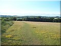
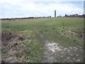
Meadow near Scholes
Looking north from a flower meadow which was in the past part of the wooded Scholes coppice.
Image: © Jonathan Clitheroe
Taken: 11 Jun 2011
0.15 miles
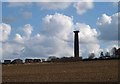
5
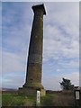
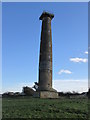
Kepples column
Monument alongside the Rotherham ring route.
Image: © steven ruffles
Taken: 8 Feb 2013
0.17 miles
6
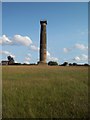
Keppel's Column
Ubiquitous local landmark which also marks the southern extent of the Wentworth estate.
Image: © Jonathan Clitheroe
Taken: 11 Jun 2011
0.17 miles
7
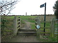
Stile on Scholes Lane
The footpath goes between Scholes village and Dropping Well. Keppel's Column Image can be seen on the crest of the hill.
Image: © Graham Hogg
Taken: 28 Nov 2011
0.17 miles
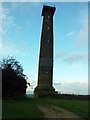
8
Keppel's column from Scholes Lane
At 115 feet, Keppel's Column is the tallest of the Wentworth follies; it was originally planned to be even taller and capped with a statue of Admiral Keppel, but evidently the Marquis of Rockingham ran short of funds! Notes from http://www.wentworthvillage.net/keppelscolumn.shtml
Image: © Steve Fareham
Taken: 30 Mar 2008
0.17 miles
9
Keppel's Column
Highest point seems to be path near gate to Keppel's Field but the column is well worth a look with Martin Richardson.
Name: Keppel's Column
Hill number: 16814
Height: 148m / 486ft
Parent (Ma/M): 2810 Black Hill
Section: 36: Lancashire, Cheshire & the Southern Pennines
County/UA: Rotherham (UA)
Class: Tump (100-199m)
Grid ref: SK 38923 94716
Summit feature: no feature: ground by path near gate
Drop: 32m
Col: 116m SK378953
Image: © Rude Health
Taken: 22 Nov 2014
0.17 miles