IMAGES TAKEN NEAR TO
Whirlow Chapel Road, ROTHERHAM, S60 8AN
Introduction
This page details the photographs taken nearby to Whirlow Chapel Road, S60 8AN by members of the Geograph project.
The Geograph project started in 2005 with the aim of publishing, organising and preserving representative images for every square kilometre of Great Britain, Ireland and the Isle of Man.

There are currently over 7.5m images from over14,400 individuals and you can help contribute to the project by visiting https://www.geograph.org.uk
Image Map
Images are licensed for reuse under creativecommons.org/licenses/by-sa/2.0
Notes
- Clicking on the map will re-center to the selected point.
- The higher the marker number, the further away the image location is from the centre of the postcode.
Image Listing (24 Images Found)
Images are licensed for reuse under creativecommons.org/licenses/by-sa/2.0
Image
Details
Distance

2

Wasteland - View over former Orgreave open cast mine workings
Image: © Neil Theasby
Taken: 27 Sep 2011
0.13 miles
3

Waverley under construction
New housing on the site of former open cast coal mine, following older Orgreave Colliery and coke plant where in 1984 striking miners and police clashed in the "Battle of Orgreave."
Image: © Chris Morgan
Taken: 4 Jan 2021
0.16 miles
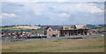
4

Housing and Business Park Development at Orgreave
Pictured from the southern edge of the grid square this picture shows regeneration on the site of the defunct Orgreave Coking Works. The Waverley Development as it is to be known will include 4000 new homes and an Advanced Manufacturing Park.
Image: © Jonathan Clitheroe
Taken: 25 Feb 2015
0.17 miles
6
Waverley Housing
These houses are the first to be built on the Waverley site. This site was the former home of Orgreave Colliery and coking ovens.
Image: © John Jennings
Taken: 18 Jul 2012
0.19 miles
8
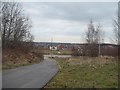
New Housing in Catcliffe
Pictured from a track near the Darnall/Woodhouse railway line.
Image: © Jonathan Clitheroe
Taken: 25 Feb 2015
0.20 miles
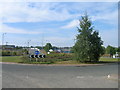
9
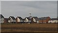
Waverley Housing Development
Houses in the early stage of a planned 3,900 home development on a brownfield site. The wind turbine is part of the associated Advanced Manufacturing Park. https://investrotherham.com/developments/waverley-community/
Image: © Graham Hogg
Taken: 4 Jan 2021
0.21 miles
10
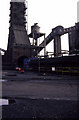
Orgreave Coking Works
The big structure with an arched opening is the quenching tower. Emerging from the hole is the blue locomotive and attached coke car (lack of smoke suggests this is not containing a freshly discharged (unquenched) load. The round structure with a conical bottom is almost certainly the quenching water header tank. The structure behind is almost certainly the coal conveying plant feeding the bunkers that charge the loading cars running on top of the battery.
Image: © Chris Allen
Taken: 4 Mar 1989
0.22 miles