IMAGES TAKEN NEAR TO
Town Street, ROTHERHAM, S60 2JR
Introduction
This page details the photographs taken nearby to Town Street, S60 2JR by members of the Geograph project.
The Geograph project started in 2005 with the aim of publishing, organising and preserving representative images for every square kilometre of Great Britain, Ireland and the Isle of Man.

There are currently over 7.5m images from over14,400 individuals and you can help contribute to the project by visiting https://www.geograph.org.uk
Image Map
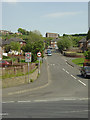
Images are licensed for reuse under creativecommons.org/licenses/by-sa/2.0
Notes
- Clicking on the map will re-center to the selected point.
- The higher the marker number, the further away the image location is from the centre of the postcode.
Image Listing (29 Images Found)
Images are licensed for reuse under creativecommons.org/licenses/by-sa/2.0
Image
Details
Distance
1

Don and Rother Valley panorama ( part 1)
Looking NNW with Rotherham centre to the right; the dark spire of the parish church is just discernible. The yellow rape fields are Barbot Hill behind which lies Greasbrough. The Canklow Road estate is just in view bottom left with the large Rank Hovis mill behind. This is one of seven pictures used to create the panorama pictureImage
Image: © Alan Murray-Rust
Taken: 11 May 2008
0.03 miles
2
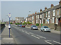
Mill Street
The north end of the Canklow Road estate. The road derives its name from the flour mill behind the photographer.
Image: © Alan Murray-Rust
Taken: 11 May 2008
0.05 miles
3

Rotherham New Life
This is a Christian centre affiliated to the Assemblies of God. The building was originally the headquarters of an engineering firm.
Image: © Alan Murray-Rust
Taken: 11 May 2008
0.05 miles
4
Canklow Road near Robinson Street
The houses beyond the office block are clearly newer than the terraces nearest the camera. They presumably replaced older housing which was considered sub-standard.
Image: © Alan Murray-Rust
Taken: 11 May 2008
0.06 miles
5
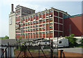
Rank Hovis flour mill
This is a distinctive landmark from this side with its bright red brick infill in concrete framing.
Image: © Alan Murray-Rust
Taken: 11 May 2008
0.09 miles
6

Rank Hovis flour mills
View from the hillside below Boston Castle
Image: © Alan Murray-Rust
Taken: 11 May 2008
0.09 miles
7

Rother View Road
The Magic map shows a continuous row of houses on this side of the road as well, possibly in the same style as those visible, but they have disappeared without trace. They have already disappeared too from the 1:25000 and 1:50000 maps.
Image: © Alan Murray-Rust
Taken: 11 May 2008
0.13 miles
8

River Rother at Canklow
Taken from the Centenary Way bridge. The footpath is part of the Trans Pennine Trail
Image: © Alan Murray-Rust
Taken: 11 May 2008
0.15 miles
9
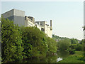
River Rother and flour mills
The Rother has now only a few tens of metres to go before joining the Don. The flour mill clearly stands on the site of a historic water mill but there are now no signs of any weir that one would have expected to accompany it.
Image: © Alan Murray-Rust
Taken: 11 May 2008
0.15 miles
10
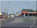
Canklow Road
The junction with Old Sheffield Road (to the left).
Image: © Alan Murray-Rust
Taken: 11 May 2008
0.16 miles