IMAGES TAKEN NEAR TO
South Grove, ROTHERHAM, S60 2AF
Introduction
This page details the photographs taken nearby to South Grove, S60 2AF by members of the Geograph project.
The Geograph project started in 2005 with the aim of publishing, organising and preserving representative images for every square kilometre of Great Britain, Ireland and the Isle of Man.

There are currently over 7.5m images from over14,400 individuals and you can help contribute to the project by visiting https://www.geograph.org.uk
Image Map
Images are licensed for reuse under creativecommons.org/licenses/by-sa/2.0
Notes
- Clicking on the map will re-center to the selected point.
- The higher the marker number, the further away the image location is from the centre of the postcode.
Image Listing (85 Images Found)
Images are licensed for reuse under creativecommons.org/licenses/by-sa/2.0
Image
Details
Distance
1
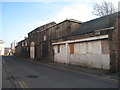
Outbuildings, Grove Street
I imagine they were once attached to a large house which has now vanished. For the courtyard side view of these outbuildings see Image]
Image: © Jonathan Thacker
Taken: 29 Jan 2011
0.05 miles
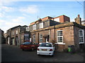
2
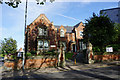
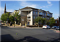
Rotherham Rural District Council Offices Grove Road built 1923
These offices on Grove Road were built for the old Rotherham Rural District Council in 1923. The original building is very smart, but there are awful 1960s additions to it.
Image: © M Parkin
Taken: Unknown
0.05 miles
3
Outbuildings, Grove Street (2)
For the street side view of these buildings see Image
Image: © Jonathan Thacker
Taken: 29 Jan 2011
0.05 miles
4
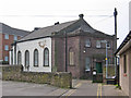
Rotherham - former school on Down's Row
This former school (with small churchyard) is tucked away at the end of a side street (Down's Row) off of Moorgate Street. The history of the school is provided on an inscribed stone in the building's exterior east wall as follows:
"In the year 1702 a school for the education of poor children in Rotherham was endowed by THOMAS HOLLIS SENR of London and afterwards by his descendants. And in 1789 THIS BUILDING was erected and the school further endowed for the same purpose, by the contributions of several of the Trustees and other Protestant Dissenters".
For more information on Thomas Hollis, please see http://www.natgould.org/Thomas_Hollis_1634-1718 .
Image: © Dave Bevis
Taken: 30 Mar 2014
0.05 miles
6
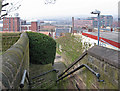
Rotherham - view west from steps to Oil Mill Fold
This view is taken from the top of the steps that connect Down's Row with Oil Mill Fold. On a clear day it should be possible to see both the old (Millmoor) and new (New York) Rotherham United Football Club's grounds and, beyond them, to the hills north of Sheffield. This was a particularly hazy day. However, the new multi-storey Rotherham Council offices are readily identifiable in the top right-hand quadrant of the photo.
Image: © Dave Bevis
Taken: 30 Mar 2014
0.06 miles
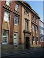
8
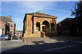
The Old Grammar School, Moorgate Road, Rotherham
Image: © Ian S
Taken: 19 Sep 2018
0.07 miles
10
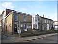
Old houses, Moorgate Street (2)
Now in commercial use.
Image: © Jonathan Thacker
Taken: 29 Jan 2011
0.08 miles