IMAGES TAKEN NEAR TO
Rotherham Road, ROTHERHAM, S60 1SG
Introduction
This page details the photographs taken nearby to Rotherham Road, S60 1SG by members of the Geograph project.
The Geograph project started in 2005 with the aim of publishing, organising and preserving representative images for every square kilometre of Great Britain, Ireland and the Isle of Man.

There are currently over 7.5m images from over14,400 individuals and you can help contribute to the project by visiting https://www.geograph.org.uk
Image Map
Images are licensed for reuse under creativecommons.org/licenses/by-sa/2.0
Notes
- Clicking on the map will re-center to the selected point.
- The higher the marker number, the further away the image location is from the centre of the postcode.
Image Listing (34 Images Found)
Images are licensed for reuse under creativecommons.org/licenses/by-sa/2.0
Image
Details
Distance
1
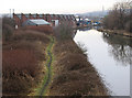
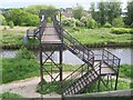
Rotherham - view from Eastwood Footbridge
This is the view west along the Don Navigation from Eastwood Footbridge (see Image for a view of the bridge itself).
Image: © Dave Bevis
Taken: 17 Jan 2011
0.04 miles
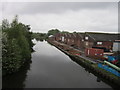
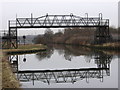
2
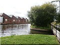
Junction of Fitzwilliam Canal and Don Navigation
A pair of swans glide through this once bustling coal terminus.
Image: © Jonathan Clitheroe
Taken: 13 Aug 2016
0.04 miles
3
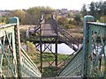
Canal Footbridge, Parkgate, Rotherham
Viewed from the Railway Footbridge ... the two bridges form a continuous public footpath over two man made obstacles. The Eastwood area of Rotherham is in the distance ... no doubt the footpath leads there - eventually. Image Image Image Image
Image: © Terry Robinson
Taken: 28 Oct 2009
0.06 miles
4
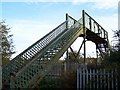
Railway Footbridge - 2, Parkgate, Rotherham
Image: © Terry Robinson
Taken: 28 Oct 2009
0.06 miles
5
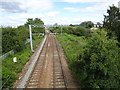
Rotherham Road railway station (site), Yorkshire
Opened in 1871 as "Park Gate" by the Manchester Sheffield & Lincolnshire Railway, which later changed its name to the Great Central Railway, on the line from Rotherham Central to Doncaster. This station's name was changed to "Rotherham Road" in 1895. It closed to passengers in 1953.
View north east towards Parkgate & Aldwarke and Doncaster. The north-east end of the 2 parallel platforms would have been immediately below the camera position but the modern Rotherham Road bridge has been built right over the top of where the station building would have been.
The line was electrified in 2018 for use by the South Yorkshire Supertram which now shares the line.
Image: © Nigel Thompson
Taken: 11 Jul 2020
0.07 miles
7
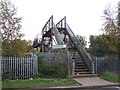
Railway Footbridge - 1, Parkgate, Rotherham
A superb example of an early Railway Footbridge ... the design is so evocative of 'the days of steam' ... a coat of paint and it would be just like new. This particular one also leads to a second bridge over the Canal. Image Image Image
Image: © Terry Robinson
Taken: 28 Oct 2009
0.09 miles
9
Rotherham - Eastwood Footbridge
This footbridge over the Don Navigation carries a path that links the Eastwood and Parkgate areas of Rotherham. To the south is a Bayley bridge crossing of the River Don (see Image) and Eastwood. To the north is a crossing of the Rotherham to Swinton railway line (see Image) and Parkgate.
Eastwood Footbridge is shown as “swing bridge” on the 2000 edition of the OS Explorer map - the existence of a swing bridge at this point is borne out by the “constriction” in the Navigation visible in the photograph.
The public footpath over Eastwood Footbridge is a good example of how a right of way has been maintained in spite of natural and man-made obstacles:
* Firstly, there must have been a man-made crossing of the River Don which linked Park Gate in the north with Eastwood in the south.
* When the Don Navigation (Rotherham Cut) was constructed in 1740 (see http://en.wikipedia.org/wiki/River_Don_Navigation ), a swing bridge (now a footbridge) was provided to maintain the right of way.
* When the MS&L railway was constructed in 1868 (see http://en.wikipedia.org/wiki/Rotherham_Central_railway_station ), a crossing was provided (now a footbridge).
* In the 1990’s, when the Parkgate Retail Park was constructed, a narrow pedestrian gap was provided in what would otherwise have been a continuous 600m row of retail units in order to preserve the right of way.
* However, this is no longer a pedestrian-friendly route – there are 96 steps on the 2 footbridges and a walker has to brave the crossing of the many car parks and service roads in the Retail Park.
* PS (Feb 2014): The footbridge has been closed, but will be replaced (see https://canalrivertrust.org.uk/notice/512/eastwood-footbridge for details).
Image: © Dave Bevis
Taken: 17 Jan 2011
0.09 miles
10
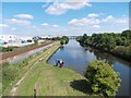
Children fishing on the Rotherham Cut
The Rotherham Cut was dug in the early nineteenth century to bypass the River Don and so enable the freer movement of industrial barge traffic.
Image: © Neil Theasby
Taken: 16 Aug 2013
0.10 miles